
File:Map of North America with the Western Interior Seaway during the Campanian (Upper Cretaceous).png

Size of this preview: 488 × 600 pixels. Other resolutions: 195 × 240 pixels | 390 × 480 pixels | 625 × 768 pixels | 833 × 1,024 pixels | 1,945 × 2,391 pixels.
Original file (1,945 × 2,391 pixels, file size: 3.95 MB, MIME type: image/png)
| This is a file from the Wikimedia Commons. Information from its description page there is shown below. Commons is a freely licensed media file repository. You can help. |
.png)
Summary
| Description |
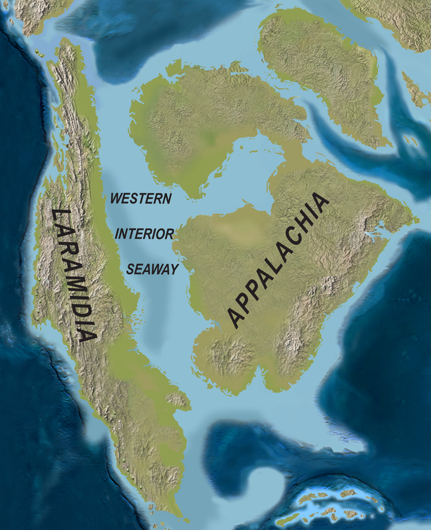
English: Map of North America with the Western Interior Seaway during the Campanian (Upper Cretaceous). Paleogeography of North America during the late Campanian Stage of the Late Cretaceous (∼75 Ma). Modified after Blakey.
Deutsch: Karte von Nordamerika mit dem Western Interior Seaway während des Campaniums (Obere Kreide) |
| Date | |
| Source | http://www.plosone.org/article/info%3Adoi%2F10.1371%2Fjournal.pone.0012292 |
| Author | Scott D. Sampson, Mark A. Loewen, Andrew A. Farke, Eric M. Roberts, Catherine A. Forster, Joshua A. Smith, Alan L. Titus |
| Permission (Reusing this file) |
http://www.plosbiology.org/static/license.action |
Licensing
This file is licensed under the Creative Commons Attribution 4.0 International license.
- You are free:
- to share – to copy, distribute and transmit the work
- to remix – to adapt the work
- Under the following conditions:
- attribution – You must give appropriate credit, provide a link to the license, and indicate if changes were made. You may do so in any reasonable manner, but not in any way that suggests the licensor endorses you or your use.
File history
Click on a date/time to view the file as it appeared at that time.
| Date/Time | Thumbnail | Dimensions | User | Comment | |
|---|---|---|---|---|---|
| current | 21:08, 1 April 2020 | | 1,945 × 2,391 (3.95 MB) | FunkMonk | {{Information |Description = {{en|1=Map of North America with the Western Interior Seaway during the Campanian (Upper Cretaceous). Paleogeography of North America during the late Campanian Stage of the Late Cretaceous (∼75 Ma). Modified after Blakey.}} {{de|1=Karte von Nordamerika mit dem Western Interior Seaway während des Campaniums (Obere Kreide)}} |Source =http://www.plosone.org/article/info%3Adoi%2F10.1371%2Fjournal.pone.0012292 |Author =Scott D. Sampson, Mark A. Loewe... |
File usage
The following pages on the English Wikipedia use this file (pages on other projects are not listed):
Global file usage
The following other wikis use this file:
- Usage on de.wiktionary.org
- Usage on fa.wikipedia.org
- Usage on fr.wikipedia.org
- Usage on id.wikipedia.org
- Usage on it.wikipedia.org
- Usage on ne.wikipedia.org
- Usage on nl.wikipedia.org
- Usage on pl.wikipedia.org
- Usage on pl.wiktionary.org
- Usage on pt.wikipedia.org
- Usage on ru.wikipedia.org
- Usage on tr.wikipedia.org
- Usage on uk.wikipedia.org
- Usage on zh.wikipedia.org
.png)