
File:Map of Luzerne County Pennsylvania School Districts.png
No higher resolution available.
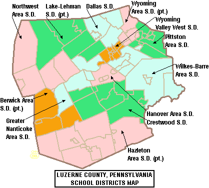
Map_of_Luzerne_County_Pennsylvania_School_Districts.png (418 × 376 pixels, file size: 18 KB, MIME type: image/png)
| This is a file from the Wikimedia Commons. Information from its description page there is shown below. Commons is a freely licensed media file repository. You can help. |
Summary
| Description |
English: Map of Luzerne County, Pennsylvania, United States Public School Districts (English)
Español: Mapa de los distritos escolares del Condado de Luzerne (inglés) |
| Date | |
| Source | taken from US Census website [1] and modified by User:Ruhrfisch / Originado del sitio web de la Oficina del Censo de los Estados Unidos, modificado por User:Ruhrfisch |
| Author | US Census, Ruhrfisch |
| Permission (Reusing this file) |
US Census / US Government work is public domain, my modifications licensed under the GNU Free Documentation License |
Licensing

|
Permission is granted to copy, distribute and/or modify this document under the terms of the GNU Free Documentation License, Version 1.2 or any later version published by the Free Software Foundation; with no Invariant Sections, no Front-Cover Texts, and no Back-Cover Texts. A copy of the license is included in the section entitled GNU Free Documentation License. |
| This file is licensed under the Creative Commons Attribution-Share Alike 3.0 Unported license. | ||
| ||
| This licensing tag was added to this file as part of the GFDL licensing update. |
File history
Click on a date/time to view the file as it appeared at that time.
| Date/Time | Thumbnail | Dimensions | User | Comment | |
|---|---|---|---|---|---|
| current | 01:04, 30 May 2006 | | 418 × 376 (18 KB) | Ruhrfisch | == Summary == {{Information| |Description= Map of Luzerne County, Pennsylvania, United States Public School Districts |Source= taken from US Census website [http://factfinder.census.gov/] and modified by User:Ruhrfisch |Date= May 2006 |Author= US Ce |
| 20:56, 22 May 2006 |  | 418 × 376 (20 KB) | Ruhrfisch | {{Information| |Description= Map of Luzerne County, Pennsylvania, United States Public School Districts |Source= taken from US Census website [http://factfinder.census.gov/] and modified by User:Ruhrfisch |Date= May 2006 |Author= US Census, Ruhrfisc |
File usage
The following pages on the English Wikipedia use this file (pages on other projects are not listed):
- Berwick Area School District
- Berwick Area Senior High School
- Butler Township, Luzerne County, Pennsylvania
- Crestwood High School (Pennsylvania)
- Crestwood School District (Pennsylvania)
- Dallas High School (Dallas, Pennsylvania)
- Dallas School District
- Elmer L. Meyers Junior/Senior High School
- G. A. R. Memorial Junior/Senior High School
- Greater Nanticoke Area School District
- Greater Pittston
- Hanover Area School District
- Hanover Township, Luzerne County, Pennsylvania
- Hazleton, Pennsylvania
- Hazleton Area School District
- Holy Redeemer High School
- James M. Coughlin High School
- Kingston, Pennsylvania
- Lake-Lehman School District
- Larksville, Pennsylvania
- Nanticoke, Pennsylvania
- Northwest Area School District
- Pittston, Pennsylvania
- Pittston Area School District
- Pittston Township, Pennsylvania
- Pringle, Pennsylvania
- Swoyersville, Pennsylvania
- West Hazleton, Pennsylvania
- West Side Career and Technology Center
- Wilkes-Barre Area High School
- Wilkes-Barre Area School District
- Wyoming Area School District
- Wyoming Seminary
- Wyoming Valley West High School
- Wyoming Valley West School District
- User:Epoloch/Projects
- Wikipedia:Articles for creation/2006-10-09
- Template:Luzerne County, Pennsylvania School Districts
Global file usage
The following other wikis use this file:
- Usage on ar.wikipedia.org
- Usage on ca.wikipedia.org
- Usage on ceb.wikipedia.org
- Usage on cy.wikipedia.org
- Usage on es.wikipedia.org
- Usage on eu.wikipedia.org
- Usage on fr.wikipedia.org
- Usage on ga.wikipedia.org
- Usage on ht.wikipedia.org
- Usage on ja.wikipedia.org
- Usage on pl.wikipedia.org
- Usage on sv.wikipedia.org
- Usage on tt.wikipedia.org
- Usage on vi.wikipedia.org
- Usage on vo.wikipedia.org
- Usage on www.wikidata.org
- Usage on zh-min-nan.wikipedia.org