
File:Map of Lithuania-Latvia by Šliūpas.jpg

Size of this preview: 687 × 600 pixels. Other resolutions: 275 × 240 pixels | 550 × 480 pixels | 880 × 768 pixels | 1,214 × 1,060 pixels.
Original file (1,214 × 1,060 pixels, file size: 198 KB, MIME type: image/jpeg)
| This is a file from the Wikimedia Commons. Information from its description page there is shown below. Commons is a freely licensed media file repository. You can help. |
Summary
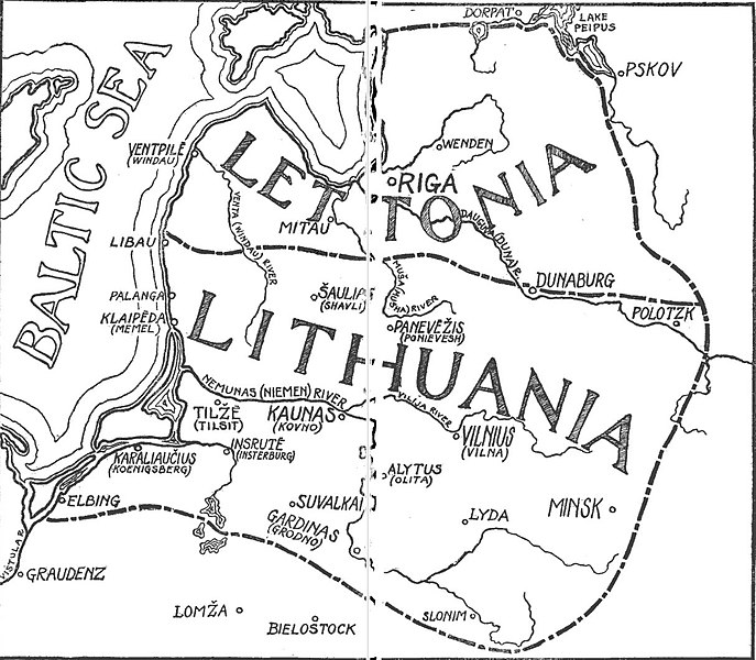
| Description | Map of Lithuania–Latvia state as envisioned and proposed by Jonas Šliūpas |
| Date | |
| Source | Lithuania in retrospect and prospect, pages 16–17 (via Google Books) |
| Author | Jonas Šliūpas |
| Permission (Reusing this file) |
PD |
Licensing
|
This work is in the public domain in its country of origin and other countries and areas where the copyright term is the author's life plus 70 years or fewer. This work is in the public domain in the United States because it was published (or registered with the U.S. Copyright Office) before January 1, 1929. | |
| This file has been identified as being free of known restrictions under copyright law, including all related and neighboring rights. | |
File history
Click on a date/time to view the file as it appeared at that time.
| Date/Time | Thumbnail | Dimensions | User | Comment | |
|---|---|---|---|---|---|
| current | 13:09, 27 January 2019 | | 1,214 × 1,060 (198 KB) | Renata3 | {{Information |Description= Map of Lithuania–Latvia state as envisioned and proposed by Jonas Šliūpas |Source= [https://books.google.com/books?id=jyE7AQAAIAAJ ''Lithuania in retrospect and prospect'', pages 16–17] (via Google Books) |Date= 1915 |Author= Jonas Šliūpas |Permission= PD |other_versions= }} Category:Jonas Šliūpas Category:Maps of Lithuania under Russian and German empires (1795-1918) |
File usage
The following pages on the English Wikipedia use this file (pages on other projects are not listed):