
File:Map of Eyre Peninsula railway lines in 1953.jpg
Size of this preview: 800 × 595 pixels. Other resolutions: 320 × 238 pixels | 640 × 476 pixels | 1,024 × 761 pixels | 1,280 × 951 pixels | 2,560 × 1,903 pixels | 4,492 × 3,339 pixels.
Original file (4,492 × 3,339 pixels, file size: 5.98 MB, MIME type: image/jpeg)
| This is a file from the Wikimedia Commons. Information from its description page there is shown below. Commons is a freely licensed media file repository. You can help. |
Summary
| Description |
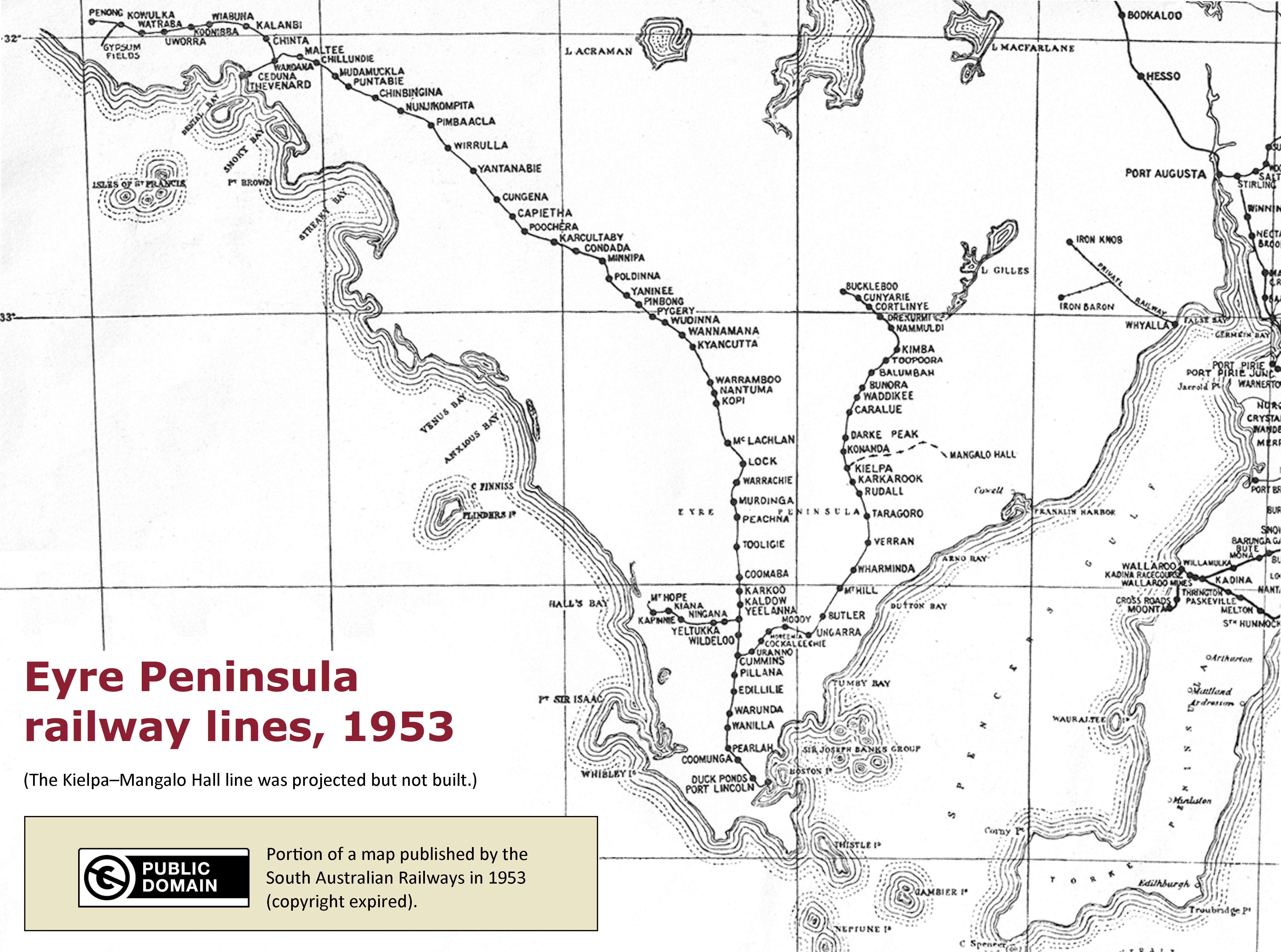
English: Map of Eyre Peninsula railway lines in 1953. |
| Date | |
| Source | Released (in its own right) as a hard copy by the South Australian Railways (an agency of the South Australian Government) in 1953. The record is in the public domain. The website of State Records of South Australia (https://www.archives.sa.gov.au/content/copyright) states "Photographs, maps and plans created before 1st May 1969: copyright has expired if made before 1st January 1955." |
| Author | No author |
Licensing
| This file is made available under the Creative Commons CC0 1.0 Universal Public Domain Dedication. | |
| The person who associated a work with this deed has dedicated the work to the public domain by waiving all of their rights to the work worldwide under copyright law, including all related and neighboring rights, to the extent allowed by law. You can copy, modify, distribute and perform the work, even for commercial purposes, all without asking permission.
|
File history
Click on a date/time to view the file as it appeared at that time.
| Date/Time | Thumbnail | Dimensions | User | Comment | |
|---|---|---|---|---|---|
| current | 12:09, 20 September 2017 | | 4,492 × 3,339 (5.98 MB) | SCHolar44 | Note added to explain meaning of dotted line representing a railway line that was never built; slight consequent adjustments to spacing of text at bottom left of image. |
| 18:59, 18 September 2017 |  | 4,499 × 3,432 (6.19 MB) | SCHolar44 | User created page with UploadWizard |
File usage
The following pages on the English Wikipedia use this file (pages on other projects are not listed):