
File:Map elk chase kansas.jpg
No higher resolution available.
Map_elk_chase_kansas.jpg (499 × 397 pixels, file size: 63 KB, MIME type: image/jpeg)
| This is a file from the Wikimedia Commons. Information from its description page there is shown below. Commons is a freely licensed media file repository. You can help. |
Summary
| Description |
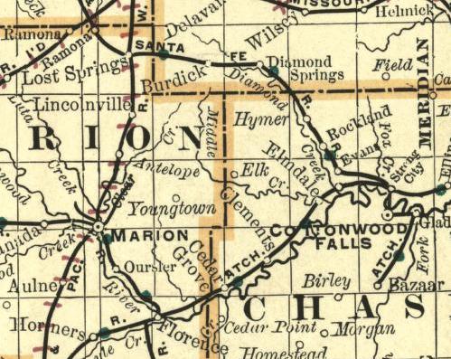
English: Part of a map of Kansas. Showing the ghost town Elk on the border between Chase County and Marion County. Image from an 1893 Map. |
| Date | |
| Source | http://alabamamaps.ua.edu/historicalmaps/us_states/kansas/index.html |
| Author | Chicago: Rand Mcnally and Company's Enlarged Business Atlas and Shippers |
Licensing
This media file is in the public domain in the United States. This applies to U.S. works where the copyright has expired, often because its first publication occurred prior to January 1, 1929, and if not then due to lack of notice or renewal. See this page for further explanation.
|
 | |
 |
This image might not be in the public domain outside of the United States; this especially applies in the countries and areas that do not apply the rule of the shorter term for US works, such as Canada, Mainland China (not Hong Kong or Macao), Germany, Mexico, and Switzerland. The creator and year of publication are essential information and must be provided. See Wikipedia:Public domain and Wikipedia:Copyrights for more details.
|
File history
Click on a date/time to view the file as it appeared at that time.
| Date/Time | Thumbnail | Dimensions | User | Comment | |
|---|---|---|---|---|---|
| current | 09:57, 25 June 2009 | | 499 × 397 (63 KB) | Polargeo | {{Information |Description={{en|1=Part of a map of Kansas. Showing the ghost town Elk on the border between Chase County and Marion County. Image from an 1893 Map.}} |Source=http://alabamamaps.ua.edu/historicalmaps/us_states/kansas/index.html |Author=Chic |
File usage
The following pages on the English Wikipedia use this file (pages on other projects are not listed):
Global file usage
The following other wikis use this file:
- Usage on ar.wikipedia.org
- Usage on fa.wikipedia.org
- Usage on ja.wikipedia.org
- Usage on simple.wikipedia.org
- Usage on www.wikidata.org
- Usage on zh.wikipedia.org