
File:Map ancient athens.png
Size of this preview: 800 × 600 pixels. Other resolutions: 320 × 240 pixels | 640 × 480 pixels | 1,000 × 750 pixels.
Original file (1,000 × 750 pixels, file size: 39 KB, MIME type: image/png)
| This is a file from the Wikimedia Commons. Information from its description page there is shown below. Commons is a freely licensed media file repository. You can help. |
Summary
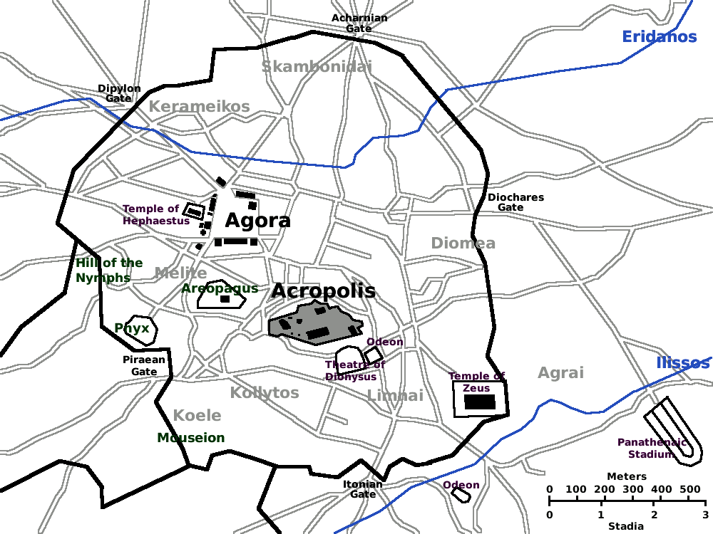
| Description | Map of Ancient Athens c. 430 BC. (Athen, Athenes, Atene, Atenas). Based on the Image:Karte Athen MKL1888.png from the 1888 edition of Meyers Konversationslexikon. Revised with modern updates, but not showing the Roman-era features. |
| Date | |
| Source | Own work |
| Author | Singinglemon |
| Permission (Reusing this file) |
Public domain |
| Other versions |
|


Licensing
| I, the copyright holder of this work, release this work into the public domain. This applies worldwide. In some countries this may not be legally possible; if so: I grant anyone the right to use this work for any purpose, without any conditions, unless such conditions are required by law. |
File history
Click on a date/time to view the file as it appeared at that time.
| Date/Time | Thumbnail | Dimensions | User | Comment | |
|---|---|---|---|---|---|
| current | 20:33, 12 March 2008 | | 1,000 × 750 (39 KB) | Singinglemon | |
| 02:58, 5 March 2008 |  | 1,000 × 750 (39 KB) | Singinglemon | ||
| 22:23, 4 March 2008 |  | 1,000 × 750 (39 KB) | Singinglemon | {{Information |Description=Map of Ancient Athens c. 430 BC. (Athen, Athenes, Atene, Atenas) |Source=self-made |Date=5 March 2008 |Author= Singinglemon |Permission=Public domain |other_versions= }} Category:Maps of Athens |
File usage
The following pages on the English Wikipedia use this file (pages on other projects are not listed):
Global file usage
The following other wikis use this file:
- Usage on ar.wikipedia.org
- Usage on be.wikipedia.org
- Usage on bg.wikipedia.org
- Usage on bs.wikipedia.org
- Usage on cs.wikipedia.org
- Usage on de.wikipedia.org
- Usage on el.wikiquote.org
- Usage on es.wikipedia.org
- Usage on fi.wikipedia.org
- Usage on fr.wikipedia.org
- Usage on hr.wikipedia.org
- Usage on hyw.wikipedia.org
- Usage on io.wikipedia.org
- Usage on it.wikipedia.org
- Usage on ja.wikipedia.org
- Usage on ko.wikipedia.org
- Usage on pt.wikipedia.org
- Usage on ru.wikipedia.org
- Usage on sh.wikipedia.org
- Usage on sl.wikipedia.org
- Usage on sv.wikipedia.org
- Usage on sv.wikivoyage.org
- Usage on ta.wikipedia.org
- Usage on uk.wikipedia.org
- Usage on www.wikidata.org