
File:Map TDWR.svg

Size of this PNG preview of this SVG file: 800 × 521 pixels. Other resolutions: 320 × 208 pixels | 640 × 417 pixels | 1,024 × 667 pixels | 1,280 × 833 pixels | 2,560 × 1,666 pixels | 911 × 593 pixels.
Original file (SVG file, nominally 911 × 593 pixels, file size: 345 KB)
| This is a file from the Wikimedia Commons. Information from its description page there is shown below. Commons is a freely licensed media file repository. You can help. |
Summary
| Description |
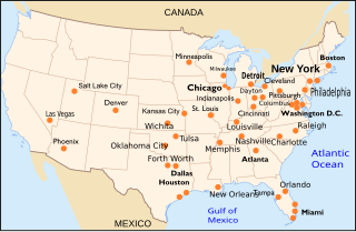
English: Map of Terminal Doppler Weather Radar network in United States. Ther is another one in San Juan, Puerto Rico. |
| Date | |
| Source | Own work |
| Author | Pierre cb done using File:Carte des villes américaines.svg as Background, data from Lincoln Laboratory, NWS and Weather Underground |
| Other versions |
This file was derived from: Maps TDWR fr.svg |
| SVG development |
Licensing
I, the copyright holder of this work, hereby publish it under the following licenses:

|
Permission is granted to copy, distribute and/or modify this document under the terms of the GNU Free Documentation License, Version 1.2 or any later version published by the Free Software Foundation; with no Invariant Sections, no Front-Cover Texts, and no Back-Cover Texts. A copy of the license is included in the section entitled GNU Free Documentation License. |
This file is licensed under the Creative Commons Attribution-Share Alike 3.0 Unported, 2.5 Generic, 2.0 Generic and 1.0 Generic license.
- You are free:
- to share – to copy, distribute and transmit the work
- to remix – to adapt the work
- Under the following conditions:
- attribution – You must give appropriate credit, provide a link to the license, and indicate if changes were made. You may do so in any reasonable manner, but not in any way that suggests the licensor endorses you or your use.
- share alike – If you remix, transform, or build upon the material, you must distribute your contributions under the same or compatible license as the original.
You may select the license of your choice.
File history
Click on a date/time to view the file as it appeared at that time.
| Date/Time | Thumbnail | Dimensions | User | Comment | |
|---|---|---|---|---|---|
| current | 19:29, 22 August 2017 | | 911 × 593 (345 KB) | Pierre cb | Add Mexico. |
| 02:29, 22 August 2017 |  | 911 × 593 (345 KB) | Pierre cb | Translating some terms. | |
| 17:54, 17 February 2017 |  | 911 × 593 (349 KB) | Pierre cb | Correcting Norman for OKC with reference (https://www.roc.noaa.gov/wsr88d/maps.aspx) | |
| 02:38, 15 April 2013 |  | 911 × 593 (349 KB) | Pierre cb | Correcting position of Milwaukee. Changing Melbourne for Orlando in Florida according to http://www.ll.mit.edu/mission/aviation/faawxsystems/images/tdwr-figure1.jpg | |
| 22:30, 28 March 2013 |  | 911 × 593 (349 KB) | Amada44 | correct the position of Milwaukee | |
| 14:09, 19 September 2009 |  | 908 × 593 (431 KB) | Pierre cb | {{Information |Description={{en|1=Map of Terminal Doppler Weather Radar network in United States. Ther is another one in San Juan, Puerto Rico.}} |Source=travail personnel (own work) |Author=[[User:Pierre cb|Pierre c |
File usage
The following pages on the English Wikipedia use this file (pages on other projects are not listed):