
File:Map Kumano Kodo (ja).png
No higher resolution available.
Map_Kumano_Kodo_(ja).png (640 × 480 pixels, file size: 72 KB, MIME type: image/png)
| This is a file from the Wikimedia Commons. Information from its description page there is shown below. Commons is a freely licensed media file repository. You can help. |
.png)
Summary
| Description |
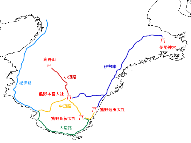
日本語: 熊野古道の地図
ja::画像:JpLargeMap_Kinki.pngから作成。
English: Map of the old roads of Kumano, medieval pilgrimage routes. Red icons are shrines and temples that the roads begin and terminate at. |
| Date | 23 September 2004 (original upload date) |
| Source | Transferred from ja.wikipedia to Commons. |
| Author | The original uploader was Yosemite at Japanese Wikipedia. |
| Other versions |
 |
Licensing
| This work has been released into the public domain by its author, Yosemite. This applies worldwide. In some countries this may not be legally possible; if so: |
Original upload log
The original description page was here. All following user names refer to ja.wikipedia.
- 2004-09-23 08:14 Yosemite 640×480×8 (73413 bytes) 熊野古道の地図
File history
Click on a date/time to view the file as it appeared at that time.
| Date/Time | Thumbnail | Dimensions | User | Comment | |
|---|---|---|---|---|---|
| current | 03:39, 7 May 2008 | | 640 × 480 (72 KB) | File Upload Bot (Magnus Manske) | {{BotMoveToCommons|ja.wikipedia}} {{Information |Description={{ja|çéå¤éã®å°å³ ja::ç»å:JpLargeMap_Kinki.pngããä½æã}} |Source=Transferred from [http://ja.wikipedia.org ja.wikipedia] |Date |
File usage
The following pages on the English Wikipedia use this file (pages on other projects are not listed):
Global file usage
The following other wikis use this file:
- Usage on ja.wikipedia.org
- Usage on zh-yue.wikipedia.org
- Usage on zh.wikipedia.org
.png)