
File:Map Iberian Peninsula 1000-es.svg

Size of this PNG preview of this SVG file: 800 × 555 pixels. Other resolutions: 320 × 222 pixels | 640 × 444 pixels | 1,024 × 711 pixels | 1,280 × 888 pixels | 2,560 × 1,777 pixels | 827 × 574 pixels.
Original file (SVG file, nominally 827 × 574 pixels, file size: 243 KB)
| This is a file from the Wikimedia Commons. Information from its description page there is shown below. Commons is a freely licensed media file repository. You can help. |
Summary
| Description |
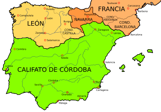
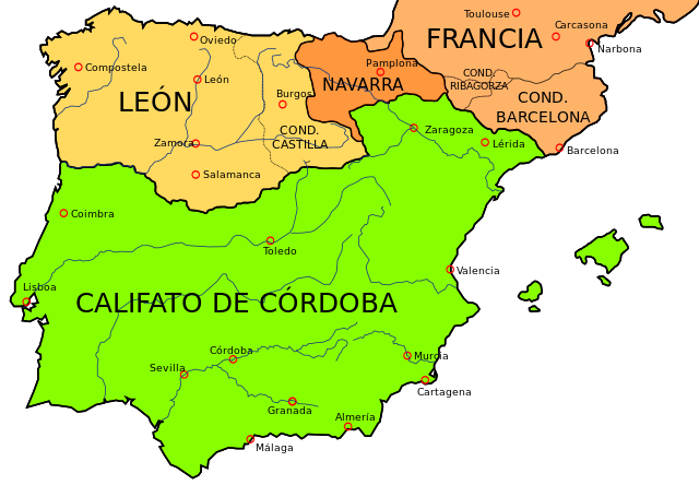
English: Map of the Iberian Peninsula in 1000
Esperanto: Mapo de la Ibera duoninsulo en la jaro 1000
Español: Mapa de la peninsula ibérica en el año 1000
Русский: Карта Пиренейского полуострова в 1000 году |
| Date | |
| Source | File:España1000.jpg, part of this map, liberated to the public domain by the University of Texas |
| Author | Crates |
| Other versions |
[]
See also
|


Licensing
I, the copyright holder of this work, hereby publish it under the following licenses:

|
Permission is granted to copy, distribute and/or modify this document under the terms of the GNU Free Documentation License, Version 1.2 or any later version published by the Free Software Foundation; with no Invariant Sections, no Front-Cover Texts, and no Back-Cover Texts. A copy of the license is included in the section entitled GNU Free Documentation License. |
This file is licensed under the Creative Commons Attribution-Share Alike 4.0 International, 3.0 Unported, 2.5 Generic, 2.0 Generic and 1.0 Generic license.
- You are free:
- to share – to copy, distribute and transmit the work
- to remix – to adapt the work
- Under the following conditions:
- attribution – You must give appropriate credit, provide a link to the license, and indicate if changes were made. You may do so in any reasonable manner, but not in any way that suggests the licensor endorses you or your use.
- share alike – If you remix, transform, or build upon the material, you must distribute your contributions under the same or compatible license as the original.
You may select the license of your choice.
File history
Click on a date/time to view the file as it appeared at that time.
| Date/Time | Thumbnail | Dimensions | User | Comment | |
|---|---|---|---|---|---|
| current | 20:19, 17 October 2022 | | 827 × 574 (243 KB) | Archiwald | File uploaded using svgtranslate tool (https://svgtranslate.toolforge.org/). Added translation for pl. |
| 16:49, 16 March 2009 |  | 827 × 574 (236 KB) | Rastrojo | Rivagorza -> Ribagorza | |
| 22:47, 19 January 2009 |  | 827 × 574 (234 KB) | Phirosiberia | {{Information |Description= |Source= |Date= |Author= |Permission= |other_versions= }} | |
| 22:44, 19 January 2009 |  | 827 × 574 (234 KB) | Phirosiberia | {{Information |Description={{en|1=Map of the Iberian Peninsula in 1000.}} {{es|1=Mapa de la peninsula ibérica en el año 1000.}} |Source=File:España1000.jpg, part of [http://www.lib.utexas.edu/maps/historical/shepherd_1911/shepherd-c-058-059.jpg th |
File usage
The following pages on the English Wikipedia use this file (pages on other projects are not listed):
Global file usage
The following other wikis use this file:
- Usage on ar.wikipedia.org
- Usage on ast.wikipedia.org
- Usage on azb.wikipedia.org
- Usage on br.wikipedia.org
- Usage on el.wikipedia.org
- Usage on eo.wikipedia.org
- Usage on es.wikipedia.org
- Castilla
- Marca Hispánica
- Batalla de Simancas
- Señorío de Vizcaya
- Reino de Pamplona
- Condado de Castilla
- Bermudo II de León
- Historia de Barcelona
- Discusión:Castilla
- Historia del País Vasco
- Subh
- Al-Ándalus
- Batalla de Cervera
- Batalla de Albesa
- Batalla de Rueda
- Batalla de Aqbat al-Bakr
- Batalla de Rovirans
- Historia de la provincia de Zamora
- Historia de la provincia de Valladolid
- Hermenegildo González
- Gonzalo Menéndez (conde)
- Usuario:Villacastrojimeno/Taller
- Genicera
- Batalla de Torá
- Alta Edad Media de la península ibérica
- Usage on eu.wikipedia.org
- Usage on fi.wikipedia.org
- Usage on it.wikipedia.org
- Usage on la.wikipedia.org
- Usage on lt.wikipedia.org
- Usage on nl.wikipedia.org
- Usage on pl.wikipedia.org
View more global usage of this file.