
File:MapHellesWarZoneGallipoli1915.jpg
Size of this preview: 748 × 600 pixels. Other resolutions: 299 × 240 pixels | 599 × 480 pixels | 1,000 × 802 pixels.
Original file (1,000 × 802 pixels, file size: 201 KB, MIME type: image/jpeg)
| This is a file from the Wikimedia Commons. Information from its description page there is shown below. Commons is a freely licensed media file repository. You can help. |
Summary
| Description |
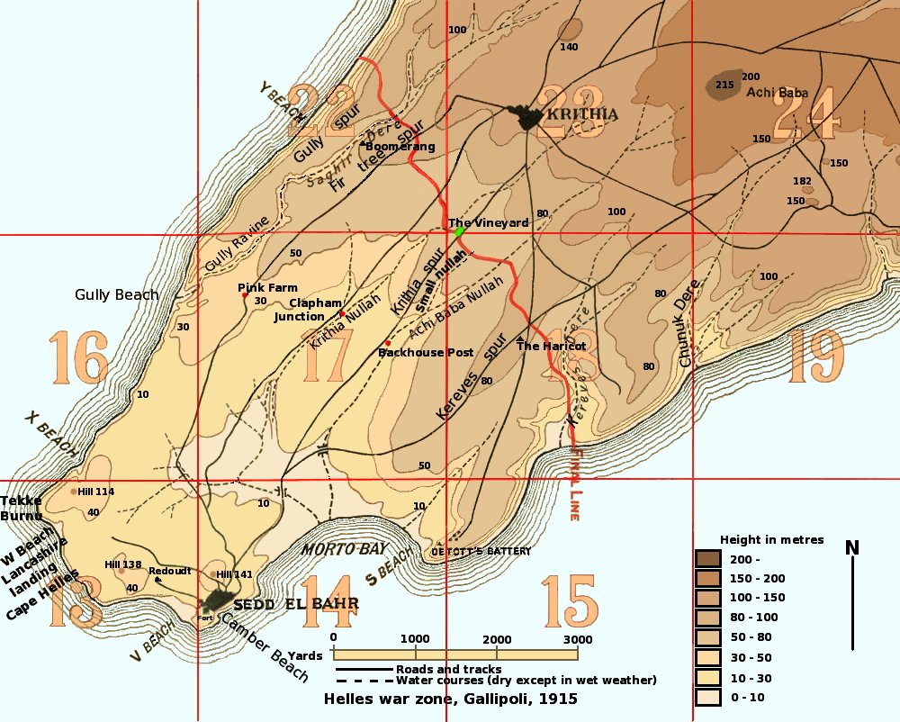
Map of the Helles war zone of Gallipoli, 1915.
|
| Date | |
| Source | Own work, based on map in "Gallipoli Diary" Volume I, General Sir Ian Hamilton, published by George H Doran Company, New York, 1920; maps in "The 42nd (East Lancashire) Division 1914-1918", Frederick P Gibbon, Country Life, London, 1920; maps in "History of the Royal Regiment of Artillery. The Forgotten Fronts and the Home Base, 1914-18", General Sir Martin Farndale, published by The Royal Artillery Association, 1988. |
| Author | Rcbutcher |
Licensing
| This work has been released into the public domain by its author, Rcbutcher at English Wikipedia. This applies worldwide. In some countries this may not be legally possible; if so: Rcbutcher grants anyone the right to use this work for any purpose, without any conditions, unless such conditions are required by law. |
File history
Click on a date/time to view the file as it appeared at that time.
| Date/Time | Thumbnail | Dimensions | User | Comment | |
|---|---|---|---|---|---|
| current | 04:30, 28 May 2008 | | 1,000 × 802 (201 KB) | Rcbutcher | e3nhanced original image optimised for screen set to gamma = 1.0 |
| 04:35, 23 May 2008 |  | 1,000 × 802 (234 KB) | Rcbutcher | Previous version was not bright enough because it was designed for display on screen set to gamma 0.5. Most people use screens with gamma set to 1.0 so this version is enhanced for gamma 1.0 | |
| 07:04, 1 December 2007 |  | 1,000 × 802 (204 KB) | Rcbutcher | ||
| 07:47, 13 October 2007 |  | 1,000 × 802 (203 KB) | Rcbutcher | ||
| 14:22, 18 September 2007 |  | 1,000 × 802 (202 KB) | Rcbutcher | ||
| 02:27, 16 September 2007 |  | 1,000 × 802 (194 KB) | Rcbutcher | ||
| 19:12, 15 September 2007 |  | 1,000 × 802 (194 KB) | Rcbutcher | {{Information |Description=Map of the Helles war zone of Gallipoli, 1915. |Source=Self-made, based on map in "Gallipoli Diary" Volume I, General Sir Ian Hamilton, published by George H Doran Company, New York, 1920. |Date=September 16 2006 |Author=~~~ |Pe |
File usage
The following pages on the English Wikipedia use this file (pages on other projects are not listed):
- 42nd (East Lancashire) Infantry Division
- 5th Battalion, Manchester Regiment
- Battle of Gully Ravine
- Battle of Krithia
- Battle of Krithia Vineyard
- First Battle of Krithia
- HMS Implacable (1899)
- Landing at Cape Helles
- Morto Bay
- Second Battle of Krithia
- Third Battle of Krithia
- User:GerardM/Battles including the Ottoman Empire
Global file usage
The following other wikis use this file:
- Usage on ar.wikipedia.org
- Usage on azb.wikipedia.org
- Usage on az.wikipedia.org
- Usage on bs.wikipedia.org
- Usage on ca.wikipedia.org
- Usage on de.wikipedia.org
- Usage on el.wikipedia.org
- Usage on es.wikipedia.org
- Usage on he.wikipedia.org
- Usage on it.wikipedia.org
- Usage on nl.wikipedia.org
- Usage on ru.wikipedia.org
- Usage on sl.wikipedia.org
- Usage on tr.wikipedia.org
- Usage on www.wikidata.org