
File:Mansewood1747-1755.jpg

Size of this preview: 600 × 600 pixels. Other resolutions: 240 × 240 pixels | 480 × 480 pixels | 768 × 768 pixels.
Original file (768 × 768 pixels, file size: 145 KB, MIME type: image/jpeg)
| This is a file from the Wikimedia Commons. Information from its description page there is shown below. Commons is a freely licensed media file repository. You can help. |
Summary
| Description |
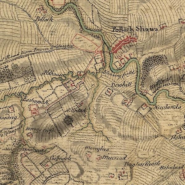
English: Mansewood as depicted in William Roy's Military Survey of Scotland 1747-1755. The Drumlin on which Mansewood is located is shown as the oval shaded area in the lower left. It is bounded by Henry's Croft farm in the South West, the original Eastwood Kirk (now Eastwood Old Cemetery) to the West, Auldhouse to the North and Hillhead House to the North East. |
|||
| Date | between 1747 and 1755 | |||
| Source |
|
|||
| Author | William Roy |


Licensing
|
This work is in the public domain in its country of origin and other countries and areas where the copyright term is the author's life plus 100 years or fewer. | |
| This file has been identified as being free of known restrictions under copyright law, including all related and neighboring rights. | |
File history
Click on a date/time to view the file as it appeared at that time.
| Date/Time | Thumbnail | Dimensions | User | Comment | |
|---|---|---|---|---|---|
| current | 15:26, 12 May 2010 | | 768 × 768 (145 KB) | Djspatrick | {{Information |Description={{en|1=Mansewood as depicted in William Roy's Military Survey of Scotland 1747-1755. The Drumlin on which Mansewood is located is shown as the oval shaded area in the lower left. It is bounded by Henry's Croft farm in the South |
File usage
The following pages on the English Wikipedia use this file (pages on other projects are not listed):
Global file usage
The following other wikis use this file:
- Usage on de.wikipedia.org
- Usage on gd.wikipedia.org
- Usage on nl.wikipedia.org
- Usage on pt.wikipedia.org