
File:Malta ali 2009224 lrg.jpg

Size of this preview: 800 × 533 pixels. Other resolutions: 320 × 213 pixels | 640 × 427 pixels | 1,024 × 683 pixels | 1,280 × 853 pixels | 2,560 × 1,706 pixels | 3,323 × 2,215 pixels.
Original file (3,323 × 2,215 pixels, file size: 3.78 MB, MIME type: image/jpeg)
| This is a file from the Wikimedia Commons. Information from its description page there is shown below. Commons is a freely licensed media file repository. You can help. |
Summary
| Description |
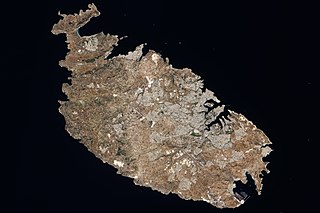
Français : L'île de Malte vue de l'espace. |
| Date | |
| Source | http://earthobservatory.nasa.gov/IOTD/view.php?id=41588 |
| Author | Unknown author |
| Camera location | | View this and other nearby images on: OpenStreetMap |
|---|
Licensing
| This file is in the public domain in the United States because it was solely created by NASA. NASA copyright policy states that "NASA material is not protected by copyright unless noted". (See Template:PD-USGov, NASA copyright policy page or JPL Image Use Policy.) | ||
 |
Warnings:
|
File history
Click on a date/time to view the file as it appeared at that time.
| Date/Time | Thumbnail | Dimensions | User | Comment | |
|---|---|---|---|---|---|
| current | 21:51, 10 March 2010 | | 3,323 × 2,215 (3.78 MB) | Thesupermat | {{Information |Description={{fr|1=L'île de Malte vue de l'espace.}} |Source=http://earthobservatory.nasa.gov/IOTD/view.php?id=41588 |Author=? |Date=2009-08-12 |Permission= |other_versions= }} Category:Satellite pictures of Malta |
File usage
The following pages on the English Wikipedia use this file (pages on other projects are not listed):
Global file usage
The following other wikis use this file:
- Usage on ast.wikipedia.org
- Usage on ca.wikipedia.org
- Usage on cs.wikipedia.org
- Usage on da.wikipedia.org
- Usage on eo.wikipedia.org
- Usage on es.wikipedia.org
- Usage on es.wiktionary.org
- Usage on fr.wikivoyage.org
- Usage on gl.wikipedia.org
- Usage on he.wikipedia.org
- Usage on hy.wikipedia.org
- Usage on lv.wikipedia.org
- Usage on pl.wikipedia.org
- Usage on ps.wikipedia.org
- Usage on ro.wikipedia.org
- Usage on sl.wikipedia.org
- Usage on th.wikipedia.org
- Usage on uk.wikivoyage.org
- Usage on www.wikidata.org
- Usage on zh.wikipedia.org