
File:Malheur Reservation map.jpg

Size of this preview: 800 × 551 pixels. Other resolutions: 320 × 221 pixels | 640 × 441 pixels | 1,024 × 706 pixels | 1,280 × 882 pixels | 1,728 × 1,191 pixels.
Original file (1,728 × 1,191 pixels, file size: 646 KB, MIME type: image/jpeg)
| This is a file from the Wikimedia Commons. Information from its description page there is shown below. Commons is a freely licensed media file repository. You can help. |
Summary
| Description |
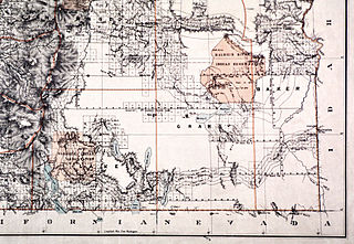
English: Map of the Malheur Reservation in eastern Oregon, U.S., an Indian reservation used for seven years in the 1870s until its inhabitants were moved elsewhere |
| Date | |
| Source | http://www.ohs.org/education/oregonhistory/historical_records/dspDocument.cfm?doc_ID=63029619-9698-B33E-18180586E8AA762E |
| Author | C. Roesser, General Land Office, Department of the Interior |
Licensing
This work is in the public domain in the United States because it is a work prepared by an officer or employee of the United States Government as part of that person’s official duties under the terms of Title 17, Chapter 1, Section 105 of the US Code.
Note: This only applies to original works of the Federal Government and not to the work of any individual U.S. state, territory, commonwealth, county, municipality, or any other subdivision. This template also does not apply to postage stamp designs published by the United States Postal Service since 1978. (See § 313.6(C)(1) of Compendium of U.S. Copyright Office Practices). It also does not apply to certain US coins; see The US Mint Terms of Use.
|
 | |
| This file has been identified as being free of known restrictions under copyright law, including all related and neighboring rights. | ||
This media file is in the public domain in the United States. This applies to U.S. works where the copyright has expired, often because its first publication occurred prior to January 1, 1929, and if not then due to lack of notice or renewal. See this page for further explanation.
|
 | |
 |
This image might not be in the public domain outside of the United States; this especially applies in the countries and areas that do not apply the rule of the shorter term for US works, such as Canada, Mainland China (not Hong Kong or Macao), Germany, Mexico, and Switzerland. The creator and year of publication are essential information and must be provided. See Wikipedia:Public domain and Wikipedia:Copyrights for more details.
|
File history
Click on a date/time to view the file as it appeared at that time.
| Date/Time | Thumbnail | Dimensions | User | Comment | |
|---|---|---|---|---|---|
| current | 21:53, 17 March 2013 | | 1,728 × 1,191 (646 KB) | Jsayre64 | {{Information |Description ={{en|1=Map of the Malheur Reservation in eastern Oregon, U.S., an Indian reservation used for seven years in the 1870s until its inhabitants were moved elsewhere}} |Source =http://www.ohs.org/education/oregonhisto... |
File usage
The following pages on the English Wikipedia use this file (pages on other projects are not listed):