
File:Malabar trogon map.png
No higher resolution available.
Malabar_trogon_map.png (299 × 297 pixels, file size: 1 KB, MIME type: image/png)
| This is a file from the Wikimedia Commons. Information from its description page there is shown below. Commons is a freely licensed media file repository. You can help. |
Summary
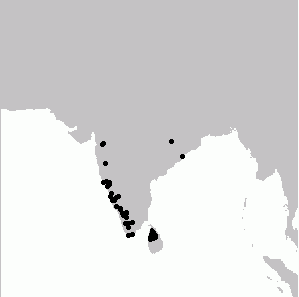
| Description | Distribution map of Malabar Trogon Harpactes fasciatus generated from BirdSpot database |
| Date | |
| Source | Own work |
| Author | L. Shyamal |
| Permission (Reusing this file) |
pd |
Licensing
| I, the copyright holder of this work, release this work into the public domain. This applies worldwide. In some countries this may not be legally possible; if so: I grant anyone the right to use this work for any purpose, without any conditions, unless such conditions are required by law. |
File history
Click on a date/time to view the file as it appeared at that time.
| Date/Time | Thumbnail | Dimensions | User | Comment | |
|---|---|---|---|---|---|
| current | 06:28, 23 September 2006 | | 299 × 297 (1 KB) | Shyamal | |
| 06:25, 23 September 2006 |  | 299 × 297 (1 KB) | Shyamal | {{Information |Description=Distribution map of Malabar Trogon generated from BirdSpot database |Source=own work |Date=September 2006 |Author=L. Shyamal |Permission=pd |other_versions= }} |
File usage
The following pages on the English Wikipedia use this file (pages on other projects are not listed):
Global file usage
The following other wikis use this file:
- Usage on ar.wikipedia.org
- Usage on arz.wikipedia.org
- Usage on ast.wikipedia.org
- Usage on bg.wikipedia.org
- Usage on ca.wikipedia.org
- Usage on ceb.wikipedia.org
- Usage on cy.wikipedia.org
- Usage on eo.wikipedia.org
- Usage on es.wikipedia.org
- Usage on eu.wikipedia.org
- Usage on fa.wikipedia.org
- Usage on fr.wikipedia.org
- Usage on ml.wikipedia.org
- Usage on nl.wikipedia.org
- Usage on ru.wikipedia.org
- Usage on sv.wikipedia.org
- Usage on ta.wikipedia.org
- Usage on uk.wikipedia.org
- Usage on www.wikidata.org