
File:Major Watersheds in Lycoming County Pennsylvania.png
Size of this preview: 800 × 542 pixels. Other resolutions: 320 × 217 pixels | 640 × 434 pixels | 823 × 558 pixels.
Original file (823 × 558 pixels, file size: 31 KB, MIME type: image/png)
| This is a file from the Wikimedia Commons. Information from its description page there is shown below. Commons is a freely licensed media file repository. You can help. |

|
This map image could be re-created using vector graphics as an SVG file. This has several advantages; see Commons:Media for cleanup for more information. If an SVG form of this image is available, please upload it and afterwards replace this template with
{{vector version available|new image name}}.
It is recommended to name the SVG file “Major Watersheds in Lycoming County Pennsylvania.svg”—then the template Vector version available (or Vva) does not need the new image name parameter. |
Summary
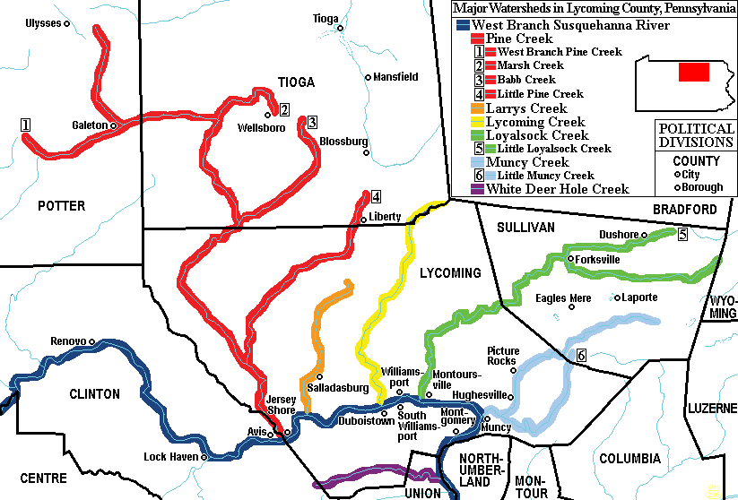
| Description | Map of Major Watersheds in Lycoming County, Pennsylvania, United States |
| Date | |
| Source | taken from US Census website [1] and modified by User:Ruhrfisch. |
| Author | US Census, Ruhrfisch |
| Permission (Reusing this file) |
US Census / US Government work is public domain, my modifications licensed under the GNU Free Documentation License |
| Other versions | four with minor errors |
Licensing
I, Ruhrfisch, the copyright holder of this work, hereby publishes it under the following license:

|
Permission is granted to copy, distribute and/or modify this document under the terms of the GNU Free Documentation License, Version 1.2 or any later version published by the Free Software Foundation; with no Invariant Sections, no Front-Cover Texts, and no Back-Cover Texts. A copy of the license is included in the section entitled GNU Free Documentation License. |
| This file is licensed under the Creative Commons Attribution-Share Alike 3.0 Unported license. | ||
| Attribution: I, Ruhrfisch | ||
| ||
| This licensing tag was added to this file as part of the GFDL licensing update. |
This image or file is a work of a United States Census Bureau employee, taken or made as part of that person's official duties. As a work of the U.S. federal government, the image is in the public domain.
|
 |
File history
Click on a date/time to view the file as it appeared at that time.
| Date/Time | Thumbnail | Dimensions | User | Comment | |
|---|---|---|---|---|---|
| current | 22:37, 22 March 2009 | | 823 × 558 (31 KB) | Mahahahaneapneap | Compressed |
| 16:13, 28 August 2006 |  | 823 × 558 (61 KB) | Ruhrfisch | {{Information |Description= Map of Major Watersheds in Lycoming County, Pennsylvania, USA. |Source= Information on river and stream positions and county boundaries is taken from US Census website[http://factfinder.census.gov/], modified by [[User:Ruhrfis | |
| 18:39, 24 August 2006 |  | 823 × 558 (62 KB) | Kmusser | ||
| 04:20, 14 March 2006 |  | 823 × 558 (30 KB) | Ruhrfisch | Map of Major Watersheds in Lycoming County Pennsylvania. Information on river and stream positions and county boundaries is taken from US Census website[http://factfinder.census.gov/] and modified by User:Ruhrfisch in March 2006 (with simplified color | |
| 17:09, 6 March 2006 |  | 823 × 558 (45 KB) | Ruhrfisch | Map of Major Watersheds in Lycoming County Pennsylvania. Information on river and stream positions and county boundaries is taken from US Census website[http://factfinder.census.gov/] and modified by User:Ruhrfisch in March 2006 (marsh Creek added). M |
File usage
The following pages on the English Wikipedia use this file (pages on other projects are not listed):
- Fair Play Men
- Larrys Creek
- Little Loyalsock Creek
- Little Muncy Creek
- Loyalsock Creek
- Lycoming County, Pennsylvania
- Lycoming Creek
- Muncy Creek
- Pine Creek (Pennsylvania)
- West Branch Susquehanna River
- West Branch Susquehanna Valley
- White Deer Hole Creek
- User:Ruhrfisch/Maps
- Wikipedia:WikiProject WikiFundi Content/White Deer Hole Creek
Global file usage
The following other wikis use this file:
- Usage on fr.wikipedia.org
- Usage on ja.wikipedia.org