
File:Major Rivers in West Canada.png

Size of this preview: 800 × 576 pixels. Other resolutions: 320 × 230 pixels | 640 × 461 pixels | 1,024 × 737 pixels | 1,280 × 922 pixels | 1,879 × 1,353 pixels.
Original file (1,879 × 1,353 pixels, file size: 2.51 MB, MIME type: image/png)
| This is a file from the Wikimedia Commons. Information from its description page there is shown below. Commons is a freely licensed media file repository. You can help. |

|
This map image could be re-created using vector graphics as an SVG file. This has several advantages; see Commons:Media for cleanup for more information. If an SVG form of this image is available, please upload it and afterwards replace this template with
{{vector version available|new image name}}.
It is recommended to name the SVG file “Major Rivers in West Canada.svg”—then the template Vector version available (or Vva) does not need the new image name parameter. |
Summary
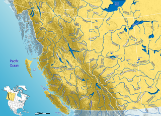
| Description | Major Rivers in western Canada |
| Date | |
| Source | GIS data |
| Author | Qyd |
| Permission (Reusing this file) |
All |
Licensing
| I, the copyright holder of this work, release this work into the public domain. This applies worldwide. In some countries this may not be legally possible; if so: I grant anyone the right to use this work for any purpose, without any conditions, unless such conditions are required by law. |
File history
Click on a date/time to view the file as it appeared at that time.
| Date/Time | Thumbnail | Dimensions | User | Comment | |
|---|---|---|---|---|---|
| current | 22:51, 30 August 2006 | | 1,879 × 1,353 (2.51 MB) | Qyd | added some lakes |
| 13:49, 26 August 2006 |  | 1,879 × 1,353 (2.5 MB) | Qyd | {{Information |Description=Majorr Rivers in western Canada |Source=GIS data |Date=Aug 2006 |Author=Qyd |Permission=All |other_versions=none }} Rivers |
File usage
The following pages on the English Wikipedia use this file (pages on other projects are not listed):
Global file usage
The following other wikis use this file:
- Usage on arz.wikipedia.org
- Usage on es.wikipedia.org
- Usage on fa.wikipedia.org
- Usage on fr.wikipedia.org
- Usage on it.wikipedia.org
- Usage on ml.wikipedia.org
- Usage on pl.wikipedia.org
- Usage on pt.wikipedia.org