
File:Main Street, downtown Smiths Grove.jpg

Size of this preview: 800 × 450 pixels. Other resolutions: 320 × 180 pixels | 640 × 360 pixels | 1,024 × 576 pixels | 1,280 × 720 pixels | 2,816 × 1,584 pixels.
Original file (2,816 × 1,584 pixels, file size: 1.02 MB, MIME type: image/jpeg)
| This is a file from the Wikimedia Commons. Information from its description page there is shown below. Commons is a freely licensed media file repository. You can help. |
| Camera location | | View this and other nearby images on: OpenStreetMap |
|---|
| Description |
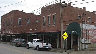
English: Buildings on the western side of Main Street (Kentucky Route 101) in Smiths Grove, Kentucky, United States. The taller buildings were constructed in 1908 (three-story) and 1915 (two-story). This block is not part of the Smiths Grove Historic District, a historic district that is listed on the National Register of Historic Places. |
||
| Date | Taken on 1 March 2014 | ||
| Source | Own work | ||
| Author | Nyttend | ||
| Permission (Reusing this file) |
|
File history
Click on a date/time to view the file as it appeared at that time.
| Date/Time | Thumbnail | Dimensions | User | Comment | |
|---|---|---|---|---|---|
| current | 19:11, 17 March 2014 | | 2,816 × 1,584 (1.02 MB) | Nyttend | {{NRHP|79003512}} {{Location|37|3|12|N|86|12|30|W}} {{Information |Description={{en|Buildings on the western side of Main Street ({{w|Kentucky Route 101}}) in {{w|Smiths Grove, Kentucky|Smiths Grove}}, {{w|Kentucky}}, {{w|United States}}. The taller b... |
File usage
The following pages on the English Wikipedia use this file (pages on other projects are not listed):
Global file usage
The following other wikis use this file:
- Usage on ar.wikipedia.org
- Usage on arz.wikipedia.org
- Usage on ca.wikipedia.org
- Usage on ce.wikipedia.org
- Usage on eu.wikipedia.org
- Usage on fr.wikipedia.org
- Usage on ht.wikipedia.org
- Usage on ky.wikipedia.org
- Usage on lld.wikipedia.org
- Usage on pl.wikipedia.org
- Usage on sr.wikipedia.org
- Usage on tt.wikipedia.org
- Usage on uz.wikipedia.org
- Usage on www.wikidata.org