
File:Maidenhead grid over Europe.svg

Size of this PNG preview of this SVG file: 729 × 599 pixels. Other resolutions: 292 × 240 pixels | 584 × 480 pixels | 934 × 768 pixels | 1,246 × 1,024 pixels | 2,492 × 2,048 pixels | 2,623 × 2,156 pixels.
Original file (SVG file, nominally 2,623 × 2,156 pixels, file size: 252 KB)
| This is a file from the Wikimedia Commons. Information from its description page there is shown below. Commons is a freely licensed media file repository. You can help. |
Summary
This W3C-unspecified vector image was created with Inkscape .
| Description |
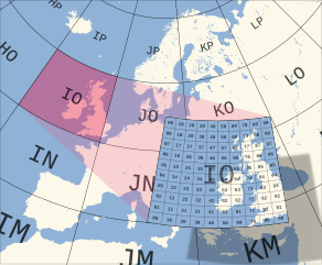
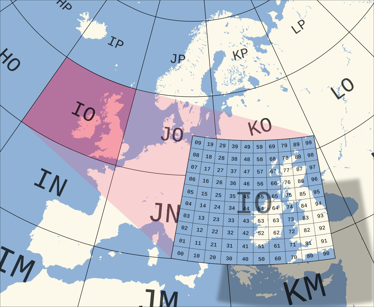
English: The Maidenhead Locator System grid over Europe. The areas marked with big letters are "fields" and the small numbers denote "squares". |
| Date | |
| Source | Base map from Image:Blank map of Europe (polar stereographic projection) cropped.svg; Grid drawn in Inkscape and based on the (public domain) output of Great Circle Maps v2.3. |
| Author | Oona Räisänen (Mysid) |
_cropped.svg)
Licensing
I, the copyright holder of this work, hereby publish it under the following licenses:

|
Permission is granted to copy, distribute and/or modify this document under the terms of the GNU Free Documentation License, Version 1.2 or any later version published by the Free Software Foundation; with no Invariant Sections, no Front-Cover Texts, and no Back-Cover Texts. A copy of the license is included in the section entitled GNU Free Documentation License. |
| This file is licensed under the Creative Commons Attribution-Share Alike 3.0 Unported license. | ||
| ||
| This licensing tag was added to this file as part of the GFDL licensing update. |
You may select the license of your choice.
File history
Click on a date/time to view the file as it appeared at that time.
| Date/Time | Thumbnail | Dimensions | User | Comment | |
|---|---|---|---|---|---|
| current | 06:52, 19 July 2010 | | 2,623 × 2,156 (252 KB) | Mysid | try Liberation Mono for a less messed-up look |
| 06:15, 19 July 2010 |  | 2,623 × 2,156 (256 KB) | Mysid | remake | |
| 15:43, 7 August 2007 |  | 1,772 × 1,906 (246 KB) | Mysid | enlarged portion showing squares | |
| 12:18, 7 August 2007 |  | 1,772 × 1,906 (179 KB) | Mysid | ==Summary== {{Information |Description=The en:Maidenhead Locator System grid over Europe. |Source=Derived from BlankMap-Europe no boundaries.svg, grid drawn in Inkscape. |Date=August 7, 2007 |Author= Mysid }} [[Category:Maps of |
File usage
The following pages on the English Wikipedia use this file (pages on other projects are not listed):
Global file usage
The following other wikis use this file:
- Usage on de.wikipedia.org
- Usage on et.wikipedia.org
- Usage on fi.wikibooks.org
- Usage on fr.wikipedia.org
- Usage on pl.wikipedia.org
- Usage on pt.wikipedia.org
- Usage on ru.wikipedia.org
- Usage on uk.wikipedia.org
- Usage on zh.wikipedia.org