
File:Maas memel etsch belt.svg

Size of this PNG preview of this SVG file: 650 × 600 pixels. Other resolutions: 260 × 240 pixels | 520 × 480 pixels | 832 × 768 pixels | 1,109 × 1,024 pixels | 2,219 × 2,048 pixels | 1,300 × 1,200 pixels.
Original file (SVG file, nominally 1,300 × 1,200 pixels, file size: 608 KB)
| This is a file from the Wikimedia Commons. Information from its description page there is shown below. Commons is a freely licensed media file repository. You can help. |
Summary
Description - Beschreibung
| Description |
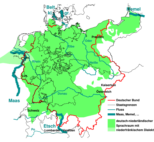
English: The German national anthem Deutschlandlied was written in 1841, giving four water bodies as borders of the German language Sprachraum of the time "Von der Maas bis an die Memel, von der Etsch bis an den Belt". This maps outlines them, and the border of the German Confederation of the time.
Deutsch: "Von der Maas bis an die Memel, von der Etsch bis an den Belt", die 4 "Grenzen" aus dem Deutschlandlied im geographisch-historischen Kontext von 1841:
Die Grenzen wurden der Karte auf der Seite Deutscher Bund entnommen und auf den Zustand 1841 vereinfacht. Die Sprachverteilung wurde stark vereinfacht aus einer Karte der Seite Deutsche Sprache entnommen und gibt den Zustand von 1910 wieder, der sich aber vermutlich nicht so stark von 1841 unterscheidet. Sie soll nur grobe Zusammenhänge zwischen damaliger Sprachverteilung zu den damaligen Grenzen aufzeigen. |
| Date | |
| Source | like File:Map-DB-Frankfurt.svg from http://www.ieg-maps.uni-mainz.de, and: File:Deutscher Bund.png, File:Historisches deutsches Sprachgebiet.PNG, File:Continental West Germanic languages.png |
| Author | Mueck |
| Other versions | |
| SVG development |


.svg)
Licensing
I, the copyright holder of this work, hereby publish it under the following licenses:

|
Permission is granted to copy, distribute and/or modify this document under the terms of the GNU Free Documentation License, Version 1.2 or any later version published by the Free Software Foundation; with no Invariant Sections, no Front-Cover Texts, and no Back-Cover Texts. A copy of the license is included in the section entitled GNU Free Documentation License. |
This file is licensed under the Creative Commons Attribution 3.0 Unported license.
- You are free:
- to share – to copy, distribute and transmit the work
- to remix – to adapt the work
- Under the following conditions:
- attribution – You must give appropriate credit, provide a link to the license, and indicate if changes were made. You may do so in any reasonable manner, but not in any way that suggests the licensor endorses you or your use.
You may select the license of your choice.
File history
Click on a date/time to view the file as it appeared at that time.
| Date/Time | Thumbnail | Dimensions | User | Comment | |
|---|---|---|---|---|---|
| current | 02:33, 11 August 2023 | | 1,300 × 1,200 (608 KB) | Amlz | Reverted to version as of 13:07, 30 May 2017 (UTC) to correct weird vector artifacts |
| 01:00, 22 July 2017 |  | 1,301 × 1,201 (652 KB) | AKAKIOS | Removed the Dutch speaking area and left only the Dutch/Low Frankish dialects in modern Germany. To add the Netherlands and Flanders to this map is inaccurate, both in its contemporary and historical context. | |
| 13:07, 30 May 2017 |  | 1,300 × 1,200 (608 KB) | Mueck | Reverted to version as of 19:16, 27 January 2011 (UTC) Indeed: Correctomundo~commonswiki produced bad quality, autotraced (or some other bad technic ...) and content: the "historic continuum" is just the interesting thing in this map ... | |
| 00:03, 12 August 2014 |  | 1,301 × 1,201 (652 KB) | Correctomundo~commonswiki | Fixed. | |
| 23:55, 11 August 2014 |  | 1,300 × 1,200 (608 KB) | Correctomundo~commonswiki | Same problem. | |
| 23:55, 11 August 2014 |  | 1,300 × 1,200 (608 KB) | Correctomundo~commonswiki | Same problem. | |
| 23:54, 11 August 2014 |  | 1,625 × 1,500 (241 KB) | Correctomundo~commonswiki | Color correction. | |
| 23:53, 11 August 2014 |  | 1,300 × 1,200 (608 KB) | Correctomundo~commonswiki | something went wrong with the colours | |
| 23:53, 11 August 2014 |  | 1,625 × 1,500 (57 KB) | Correctomundo~commonswiki | Removed Dutch and Standard Dutch influenced dialects. These are not German dialects, even though there historically was a continuum. | |
| 19:16, 27 January 2011 |  | 1,300 × 1,200 (608 KB) | NordNordWest | c |
File usage
The following pages on the English Wikipedia use this file (pages on other projects are not listed):
Global file usage
The following other wikis use this file:
- Usage on az.wikipedia.org
- Usage on cs.wikipedia.org
- Usage on de.wikipedia.org
- Usage on fi.wikipedia.org
- Usage on fr.wikipedia.org
- Usage on ka.wikipedia.org
- Usage on ko.wikipedia.org
- Usage on sr.wikipedia.org
- Usage on zh-yue.wikipedia.org
- Usage on zh.wikipedia.org