
File:Luzon Strait n7184.jpg

Size of this preview: 318 × 598 pixels. Other resolutions: 127 × 240 pixels | 542 × 1,020 pixels.
Original file (542 × 1,020 pixels, file size: 77 KB, MIME type: image/jpeg)
| This is a file from the Wikimedia Commons. Information from its description page there is shown below. Commons is a freely licensed media file repository. You can help. |
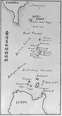
| Description | Old map of the Luzon Strait (not labeled), including the Bashi Channel, between Orchid Island (Botel Tobago on the map) of Taiwan and the Batan Islands of the Philippines. Names may be out of date. Japanese caption: "Islands between Taiwan and Luzon". | |||||
| Date | Unknown date | |||||
| Source |
From digital archive of the University of Tokyo. [1] Cropped by a-giâu. |
|||||
| Author | anthropologist Torii Ryūzō (1870-1953) | |||||
| Permission (Reusing this file) |
|


File history
Click on a date/time to view the file as it appeared at that time.
| Date/Time | Thumbnail | Dimensions | User | Comment | |
|---|---|---|---|---|---|
| current | 23:30, 11 November 2004 | | 542 × 1,020 (77 KB) | A-giâu | Old map of the Luzon Strait,(not labeled), including the Bashi Channel, between Orchid Island (Botel Tobago in the map) of Taiwan and the Batanes of the Philippines. Names may be out of date. From digital archive of the Universit |
File usage
The following pages on the English Wikipedia use this file (pages on other projects are not listed):
Global file usage
The following other wikis use this file:
- Usage on ar.wikipedia.org
- Usage on ast.wikipedia.org
- Usage on az.wikipedia.org
- Usage on bcl.wikipedia.org
- Usage on be.wikipedia.org
- Usage on ca.wikipedia.org
- Usage on ceb.wikipedia.org
- Usage on cs.wikipedia.org
- Usage on da.wikipedia.org
- Usage on de.wikipedia.org
- Usage on es.wikipedia.org
- Usage on eu.wikipedia.org
- Usage on fa.wikipedia.org
- Usage on fr.wikipedia.org
- Usage on he.wikipedia.org
- Usage on hi.wikipedia.org
- Usage on id.wikipedia.org
- Usage on ilo.wikipedia.org
- Usage on it.wikipedia.org
- Usage on ja.wikipedia.org
- Usage on ko.wikipedia.org
- Usage on lt.wikipedia.org
- Usage on mk.wikipedia.org
- Usage on nl.wikipedia.org
- Usage on no.wikipedia.org
- Usage on pam.wikipedia.org
View more global usage of this file.