
File:Luke Foxe voyage account (North-West Fox, 1635) - 2 foldout map -1 full view.png

Original file (5,742 × 4,226 pixels, file size: 39.96 MB, MIME type: image/png)
| This is a file from the Wikimedia Commons. Information from its description page there is shown below. Commons is a freely licensed media file repository. You can help. |
Summary
| Description |
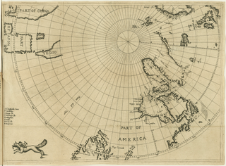
English: Fold-out engraved map from Luke Foxe's voyage account book, showing the route of his 1631 sea expedition from England (top right) in search of a Northwest passage towards Asia (top left) through Hudson Strait, exploring Hudson Bay and Foxe Basin (detail). The map uses the azimuthal equidistant projection, with the North Pole as its center point. At bottom left, near the Island of California, the map is decorated with a fox, the author's emblem.
|
||||||||||||||||||||
| Date | |||||||||||||||||||||
| Source |
Courtesy of John Carter Brown Library at Brown University
|
||||||||||||||||||||
| Creator |
|
||||||||||||||||||||
| Permission (Reusing this file) |
|
||||||||||||||||||||
| Geotemporal data | |||||||||||||||||||||
| Date depicted | |||||||||||||||||||||
| Map location | Hudson Bay, Hudson Strait, Baffin Bay, Arctic Canada, Greenland | ||||||||||||||||||||
| Map type | nautical chart | ||||||||||||||||||||
| Spatial reference system | azimuthal equidistant centered on North Pole | ||||||||||||||||||||
| Bounding box |
|
||||||||||||||||||||
| Bibliographic data | |||||||||||||||||||||
| Publication | |||||||||||||||||||||
| Page(s) | fold-out map following p. 172 | ||||||||||||||||||||
| Language | English | ||||||||||||||||||||
| Place of publication | London | ||||||||||||||||||||
| Printed by |
B. Alsop,
|
||||||||||||||||||||
| Archival data | |||||||||||||||||||||
| Collection |
|
||||||||||||||||||||
| Accession number |
29912 |
||||||||||||||||||||
| Dimensions | height: 31.7 cm (12.4 in); width: 44 cm (17.3 in) | ||||||||||||||||||||
| Medium | engraving | ||||||||||||||||||||
| artwork-references |
|
||||||||||||||||||||
| Scan resolution | 96 dpi | ||||||||||||||||||||
| Other versions |
|
||||||||||||||||||||
.svg)


_-_3_foldout_map_-_2_Hudson_Bay.png)
_-_4_foldout_map_-_3_fox.png)
_-_2_foldout_map_-1_full_view.png)
File history
Click on a date/time to view the file as it appeared at that time.
| Date/Time | Thumbnail | Dimensions | User | Comment | |
|---|---|---|---|---|---|
| current | 20:56, 28 March 2021 | | 5,742 × 4,226 (39.96 MB) | Wikipetzi | {{Map |description = {{en |1= Fold-out engraved map from {{w|Luke Foxe|Luke Foxe}}'s voyage account book, showing the route of his 1631 sea expedition from England (top right) in search of a Northwest passage towards Asia (top left) through Hudson Strait, exploring Hudson Bay and Foxe Basin. The map uses the {{w|Azimuthal equidistant projection|azimuthal equidistant projection}}, with the North Pole as its center point. At bottom left, near the {{w|Island of California|Island of Califo... |
_-_2_foldout_map_-1_full_view.png)