
File:Lower slopes of Hermaness Hill, Unst.jpg
No higher resolution available.
Lower_slopes_of_Hermaness_Hill,_Unst.jpg (640 × 479 pixels, file size: 45 KB, MIME type: image/jpeg)
| This is a file from the Wikimedia Commons. Information from its description page there is shown below. Commons is a freely licensed media file repository. You can help. |
| Camera location | | View this and other nearby images on: OpenStreetMap |
|---|
_region:GB-GBN_heading:22.00&language=en)
| Object location | | View this and other nearby images on: OpenStreetMap |
|---|
_region:GB-GBN_heading:22.00&language=en)

|
This image was taken from the Geograph project collection. See this photograph's page on the Geograph website for the photographer's contact details. The copyright on this image is owned by Bob Embleton and is licensed for reuse under the Creative Commons Attribution-ShareAlike 2.0 license.
|
This file is licensed under the Creative Commons Attribution-Share Alike 2.0 Generic license.
Attribution: Bob Embleton
- You are free:
- to share – to copy, distribute and transmit the work
- to remix – to adapt the work
- Under the following conditions:
- attribution – You must give appropriate credit, provide a link to the license, and indicate if changes were made. You may do so in any reasonable manner, but not in any way that suggests the licensor endorses you or your use.
- share alike – If you remix, transform, or build upon the material, you must distribute your contributions under the same or compatible license as the original.
60:50.6829N 0:53.3210W
| Description |
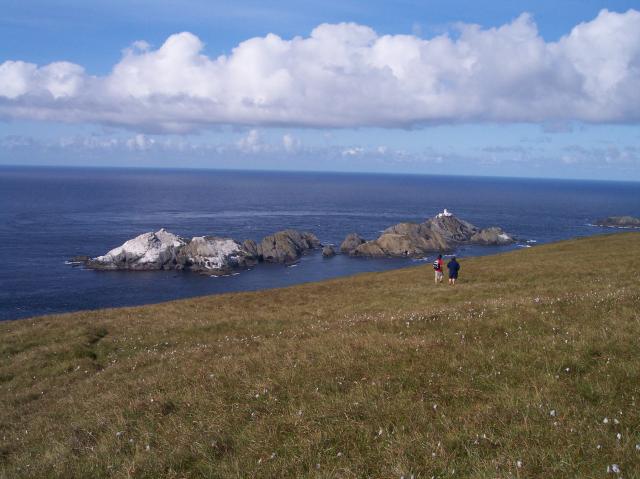
Lower slopes of Hermaness Hill, Unst From left to right, which is also from south to north: Vesta Skerry, Rumblings, Tipta Skerry, Muckle Flugga (with the lighthouse), and at the righthand edge of the picture, Out Stack. Some smaller unnamed skerries in between. |
| Date | |
| Source | https://www.geograph.org.uk/photo/2131 |
| Author | Bob Embleton |
File history
Click on a date/time to view the file as it appeared at that time.
| Date/Time | Thumbnail | Dimensions | User | Comment | |
|---|---|---|---|---|---|
| current | 23:26, 29 May 2007 | | 640 × 479 (45 KB) | Jorunn | {{geograph|2131|Bob Embleton}} 60:50.6829N 0:53.3210W {{Information |Description='''Lower slopes of Hermaness Hill, Unst'''<br> The most northerly point of the island of Unst looking out to The Skerries (in HP6019).<br>From left to right, which is also |
File usage
The following pages on the English Wikipedia use this file (pages on other projects are not listed):
Global file usage
The following other wikis use this file:
- Usage on ceb.wikipedia.org
- Usage on es.wikipedia.org
- Usage on it.wikipedia.org
- Usage on nn.wikipedia.org
- Usage on ru.wikipedia.org
- Usage on sv.wikipedia.org
- Usage on www.wikidata.org