
File:Lower Egypt-en.png

Size of this preview: 600 × 600 pixels. Other resolutions: 240 × 240 pixels | 480 × 480 pixels | 994 × 994 pixels.
Original file (994 × 994 pixels, file size: 188 KB, MIME type: image/png)
| This is a file from the Wikimedia Commons. Information from its description page there is shown below. Commons is a freely licensed media file repository. You can help. |
Summary
| Description |
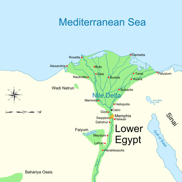
English: Map of Lower Ancient Egypt, showing the Nile and major cities and sites of the Dynastic period (c. 3150 BC to 30 BC). |
| Date | (UTC) |
| Source | |
| Author |
|
| Other versions |
Derivative works of this file: |

|
This historical map image could be re-created using vector graphics as an SVG file. This has several advantages; see Commons:Media for cleanup for more information. If an SVG form of this image is available, please upload it and afterwards replace this template with
{{vector version available|new image name}}.
It is recommended to name the SVG file “Lower Egypt-en.svg”—then the template Vector version available (or Vva) does not need the new image name parameter. |
| This is a retouched picture, which means that it has been digitally altered from its original version. Modifications: Cropped image to use as base map. The original can be viewed here: Ancient Egypt map-en.svg:
|
Licensing
I, the copyright holder of this work, hereby publish it under the following licenses:
This file is licensed under the Creative Commons Attribution-Share Alike 3.0 Unported, 2.5 Generic, 2.0 Generic and 1.0 Generic license.
- You are free:
- to share – to copy, distribute and transmit the work
- to remix – to adapt the work
- Under the following conditions:
- attribution – You must give appropriate credit, provide a link to the license, and indicate if changes were made. You may do so in any reasonable manner, but not in any way that suggests the licensor endorses you or your use.
- share alike – If you remix, transform, or build upon the material, you must distribute your contributions under the same or compatible license as the original.

|
Permission is granted to copy, distribute and/or modify this document under the terms of the GNU Free Documentation License, Version 1.2 or any later version published by the Free Software Foundation; with no Invariant Sections, no Front-Cover Texts, and no Back-Cover Texts. A copy of the license is included in the section entitled GNU Free Documentation License. |
You may select the license of your choice.
Original upload log
This image is a derivative work of the following images:
- File:Ancient_Egypt_map-en.svg licensed with Cc-by-sa-3.0,2.5,2.0,1.0, GFDL
- 2009-02-20T11:28:29Z Bibi Saint-Pol 1577x3219 (422457 Bytes) fix translation mistake on the windrose
- 2009-01-30T12:13:53Z Bibi Saint-Pol 1577x3219 (422444 Bytes) fix position of Nile Delta
- 2009-01-29T12:21:11Z Bibi Saint-Pol 1577x3219 (422383 Bytes) remove wrong text, adjust frame
- 2009-01-29T12:05:11Z Bibi Saint-Pol 1577x3219 (422757 Bytes) {{Assessments|1=Ancient Egypt map.svg|enwiki=1}} __NOTOC__ == {{int:filedesc}} == {{inkscape}} {{Information |Description= {{en|Map of Ancient Egypt, showing the Nile up to the fifth cataract, and major cities and sites of th
Uploaded with derivativeFX
File history
Click on a date/time to view the file as it appeared at that time.
| Date/Time | Thumbnail | Dimensions | User | Comment | |
|---|---|---|---|---|---|
| current | 16:30, 14 February 2014 | | 994 × 994 (188 KB) | Andy king50 | -border |
| 18:00, 29 June 2009 |  | 1,000 × 1,000 (193 KB) | MinisterForBadTimes | Hopefully fixed border this time | |
| 17:59, 29 June 2009 |  | 1,000 × 1,000 (193 KB) | MinisterForBadTimes | Moved border | |
| 17:57, 29 June 2009 |  | 1,000 × 1,000 (193 KB) | MinisterForBadTimes | Added border | |
| 17:49, 29 June 2009 |  | 1,000 × 1,000 (190 KB) | MinisterForBadTimes | {{Information |Description={{en|Map of Lower Ancient Egypt, showing the Nile and major cities and sites of the Dynastic period (c. 3150 BC to 30 BC). |Source=*File:Ancient_Egypt_map-en.svg |Date=2009-06-29 18:49 (UTC) |Author=*[[:File:Ancient_Egypt_ |
File usage
The following pages on the English Wikipedia use this file (pages on other projects are not listed):
Global file usage
The following other wikis use this file:
- Usage on ar.wikipedia.org
- Usage on arz.wikipedia.org
- Usage on az.wikipedia.org
- Usage on bg.wikipedia.org
- Usage on br.wikipedia.org
- Usage on cs.wikipedia.org
- Usage on de.wikipedia.org
- Usage on de.wikivoyage.org
- Usage on el.wikipedia.org
- Usage on es.wikipedia.org
- Usage on et.wikipedia.org
- Usage on eu.wikipedia.org
- Usage on fr.wikipedia.org
- Usage on he.wikipedia.org
- Usage on hu.wikipedia.org
- Usage on it.wikipedia.org
- Usage on ja.wikipedia.org
- Usage on ja.wikibooks.org
- Usage on ko.wikipedia.org
- Usage on la.wikipedia.org
- Usage on nl.wikipedia.org
- Usage on no.wikipedia.org
- Usage on pl.wikipedia.org
View more global usage of this file.