
File:London Underground Zone 2.png

Size of this preview: 800 × 564 pixels. Other resolutions: 320 × 226 pixels | 640 × 451 pixels | 1,024 × 722 pixels | 1,280 × 902 pixels.
Original file (1,280 × 902 pixels, file size: 365 KB, MIME type: image/png)
| This is a file from the Wikimedia Commons. Information from its description page there is shown below. Commons is a freely licensed media file repository. You can help. |
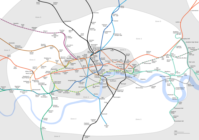
Generated as part of the London Underground geographic maps project by software written by ed g2s • talk and James D. Forrester utilising GPS data.
NB: Routes between stations are interpolated and may not be geographically accurate

|
Permission is granted to copy, distribute and/or modify this document under the terms of the GNU Free Documentation License, Version 1.2 or any later version published by the Free Software Foundation; with no Invariant Sections, no Front-Cover Texts, and no Back-Cover Texts. A copy of the license is included in the section entitled GNU Free Documentation License. |
| This file is licensed under the Creative Commons Attribution-Share Alike 3.0 Unported license. | ||
| ||
| This licensing tag was added to this file as part of the GFDL licensing update. |
This file is licensed under the Creative Commons Attribution-Share Alike 2.5 Generic, 2.0 Generic and 1.0 Generic license.
- You are free:
- to share – to copy, distribute and transmit the work
- to remix – to adapt the work
- Under the following conditions:
- attribution – You must give appropriate credit, provide a link to the license, and indicate if changes were made. You may do so in any reasonable manner, but not in any way that suggests the licensor endorses you or your use.
- share alike – If you remix, transform, or build upon the material, you must distribute your contributions under the same or compatible license as the original.
File history
Click on a date/time to view the file as it appeared at that time.
| Date/Time | Thumbnail | Dimensions | User | Comment | |
|---|---|---|---|---|---|
| current | 23:10, 4 February 2018 | | 1,280 × 902 (365 KB) | DavidCane | Revise to correspond to svg version. Add circle line to Hammersmith, add Wood Lane, rename Shepherd's Bush to Shepherd's Bush Market, add Stratford branch to DLR remove east London line, amend zone 2 boundaries |
| 12:29, 26 April 2006 |  | 1,280 × 902 (99 KB) | Ed g2s | minor fixes | |
| 21:33, 11 January 2006 |  | 1,280 × 902 (106 KB) | Ed g2s | Inverted highlights | |
| 09:20, 27 October 2005 |  | 2,000 × 1,413 (175 KB) | Ed g2s | fix swiss cottage | |
| 01:47, 28 July 2005 |  | 2,000 × 1,413 (175 KB) | Ed g2s | {{London Underground geographic map}} |
File usage
The following pages on the English Wikipedia use this file (pages on other projects are not listed):
Global file usage
The following other wikis use this file:
- Usage on ca.wikipedia.org
- Usage on de.wikipedia.org
- Usage on eo.wikipedia.org
- Usage on es.wikipedia.org
- Usage on it.wikipedia.org
- Usage on ja.wikipedia.org
- Usage on ko.wikipedia.org
- Usage on nl.wikipedia.org
- Usage on nl.wikivoyage.org
- Usage on no.wikipedia.org
- Usage on simple.wikipedia.org
- Usage on sw.wikipedia.org
- Usage on ur.wikipedia.org