
File:Loire Maine Angers2 tango7174.jpg
Size of this preview: 800 × 507 pixels. Other resolutions: 320 × 203 pixels | 640 × 405 pixels.
Original file (947 × 600 pixels, file size: 383 KB, MIME type: image/jpeg)
| This is a file from the Wikimedia Commons. Information from its description page there is shown below. Commons is a freely licensed media file repository. You can help. |
Summary
| Description |
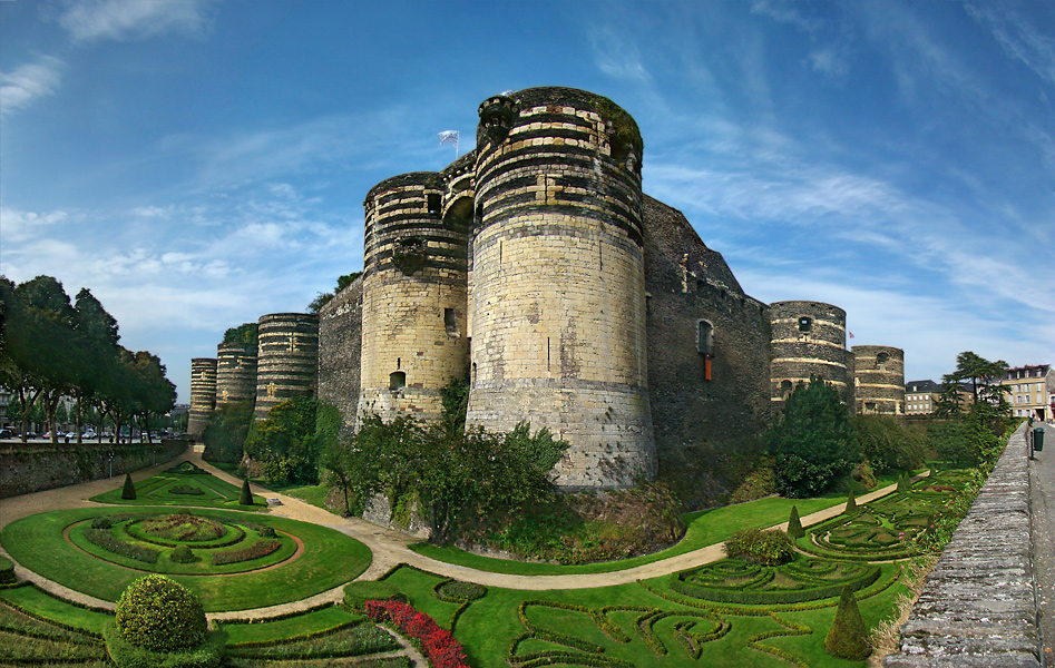
Français : Château d'Angers, Maine-et-Loire, Pays de la Loire, France. La porte des champs côté sud au premier plan, était l'entrée principale de la forteresse à l'origine.
English: Château d'Angers, Maine-et-Loire, Pays de la Loire, France. The gate of the fields on the south side in the foreground, used to be the main entrance into the fortress originally. |
| Date | |
| Source | Own work |
| Author | Tango7174 |
| Camera location | | View this and other nearby images on: OpenStreetMap |
|---|
Licensing
I, the copyright holder of this work, hereby publish it under the following licenses:

|
Permission is granted to copy, distribute and/or modify this document under the terms of the GNU Free Documentation License, Version 1.2 or any later version published by the Free Software Foundation; with no Invariant Sections, no Front-Cover Texts, and no Back-Cover Texts. A copy of the license is included in the section entitled GNU Free Documentation License. |
This file is licensed under the Creative Commons Attribution-Share Alike 4.0 International, 3.0 Unported, 2.5 Generic, 2.0 Generic and 1.0 Generic license.
- You are free:
- to share – to copy, distribute and transmit the work
- to remix – to adapt the work
- Under the following conditions:
- attribution – You must give appropriate credit, provide a link to the license, and indicate if changes were made. You may do so in any reasonable manner, but not in any way that suggests the licensor endorses you or your use.
- share alike – If you remix, transform, or build upon the material, you must distribute your contributions under the same or compatible license as the original.
You may select the license of your choice.
File history
Click on a date/time to view the file as it appeared at that time.
| Date/Time | Thumbnail | Dimensions | User | Comment | |
|---|---|---|---|---|---|
| current | 12:50, 28 October 2009 | | 947 × 600 (383 KB) | Tango7174 | == {{int:filedesc}} == {{Information |Description={{fr|Château d'Angers, Maine-et-Loire, Pays de la Loire, France. La porte des champs côté sud au premier plan, était l'entrée principale de la forteresse à l'origine.}} {{en|Château d'Angers, Maine- |
File usage
The following pages on the English Wikipedia use this file (pages on other projects are not listed):
Global file usage
The following other wikis use this file:
- Usage on ace.wikipedia.org
- Usage on als.wikipedia.org
- Usage on ar.wikipedia.org
- Usage on azb.wikipedia.org
- Usage on az.wikipedia.org
- Usage on bcl.wikipedia.org
- Usage on be-tarask.wikipedia.org
- Usage on be.wikipedia.org
- Usage on br.wikipedia.org
- Usage on ca.wikipedia.org
- Usage on ceb.wikipedia.org
- Usage on crh.wikipedia.org
- Usage on cy.wikipedia.org
- Usage on da.wikipedia.org
- Usage on de.wikipedia.org
- Usage on de.wikivoyage.org
- Usage on dsb.wikipedia.org
- Usage on el.wikipedia.org
- Usage on eo.wikipedia.org
- Usage on es.wikipedia.org
- Usage on fo.wikipedia.org
- Usage on frp.wikipedia.org
- Usage on fr.wikipedia.org
- Châteaux de la Loire
- Portail:Anjou et Maine-et-Loire
- Château fort
- Wikipédia:Sélection/Communes de France
- Wikipédia:Sélection/Architecture et Urbanisme
- Wikipédia:Sélection/Monuments historiques
- Wikipédia:Sélection/Pays de la Loire
- Wikipédia:Sélection/Châteaux de France
- Wikipédia:Lumière sur/Septembre 2011
- Wikipédia:Lumière sur/Château d'Angers
- Portail:Anjou et Maine-et-Loire/Lumière sur/11
- Wikipédia:Sélection/Protection du patrimoine
- Utilisateur:Kormin/Projet Châteaux de Maine-et-Loire
- Wikipédia:Lumière sur/Novembre 2015
- Patrimoine architectural d'Angers
- Portail:Anjou et Maine-et-Loire/Lumière sur/17
- Wikipédia:RAW/2015-12-04
- Wikipédia:Lumière sur/Angers
- Wikipédia:Sélection/France/Articles de qualité/A à K
- Wikipédia:Sélection/France/Bons articles/C à D
- Utilisateur:AURELXV3PRO
View more global usage of this file.