
File:Location NATO Russia.svg

Size of this PNG preview of this SVG file: 799 × 319 pixels. Other resolutions: 320 × 128 pixels | 640 × 256 pixels | 1,024 × 409 pixels | 1,280 × 511 pixels | 2,560 × 1,022 pixels | 949 × 379 pixels.
Original file (SVG file, nominally 949 × 379 pixels, file size: 598 KB)
| This is a file from the Wikimedia Commons. Information from its description page there is shown below. Commons is a freely licensed media file repository. You can help. |
Summary
| Description |
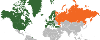
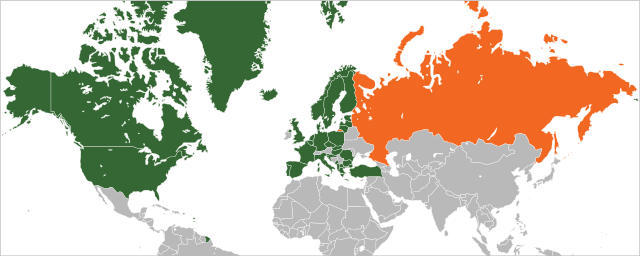
English: Member countries of NATO in green and Russia in orange |
| Date | |
| Source | Own work based on: Location NATO.svg by Ssolbergj |
| Author | Patrickneil |
| SVG development |
Licensing
I, the copyright holder of this work, hereby publish it under the following license:
This file is licensed under the Creative Commons Attribution 3.0 Unported license.
- You are free:
- to share – to copy, distribute and transmit the work
- to remix – to adapt the work
- Under the following conditions:
- attribution – You must give appropriate credit, provide a link to the license, and indicate if changes were made. You may do so in any reasonable manner, but not in any way that suggests the licensor endorses you or your use.
Original upload log
This image is a derivative work of the following images:
- Location NATO.svg licensed with Cc-by-3.0
- 2009-04-01T15:37:52Z EmilJ 616x247 (584576 Bytes) add ALB, CRO
- 2008-05-31T19:25:16Z Ssolbergj 616x247 (584395 Bytes) {{Information |Description= |Source= |Date= |Author= |Permission= |other_versions= }}
- 2008-05-31T19:22:41Z Ssolbergj 591x297 (584395 Bytes) {{Information |Description={{en|1=Member countries of NATO}} |Source=Own work by uploader |Author=[[:en:User:Ssolbergj|Ssolbergj]] |Date=31 May 2008 |Permission= |other_versions= }} {{ImageUpload|full}} [[Category:North Atla
File history
Click on a date/time to view the file as it appeared at that time.
| Date/Time | Thumbnail | Dimensions | User | Comment | |
|---|---|---|---|---|---|
| current | 07:01, 10 March 2024 | 949 × 379 (598 KB) | Santiago Claudio | +Sweden | |
| 20:33, 7 April 2023 | 949 × 379 (598 KB) | Nahabino | +Finland | ||
| 11:12, 14 September 2022 | 949 × 379 (604 KB) | Nahabino | With correct preview | ||
| 19:18, 16 August 2022 | 949 × 379 (596 KB) | Nahabino | Reverted to version as of 04:14, 12 April 2020 (UTC) | ||
| 19:16, 16 August 2022 | 949 × 379 (590 KB) | Nahabino | fix color | ||
| 19:11, 16 August 2022 | 949 × 379 (590 KB) | Nahabino | +Sweden, +Finland, -Crimea | ||
| 04:14, 12 April 2020 | 949 × 379 (596 KB) | Ratherous | North Macedonia | ||
| 18:41, 10 June 2017 | 949 × 379 (596 KB) | Ratherous | Montenegro | ||
| 10:55, 13 April 2017 | 949 × 379 (596 KB) | Seryo93 | hatched Crimea | ||
| 12:12, 30 July 2016 | 949 × 379 (591 KB) | Rob984 | Reverted to version as of 08:07, 8 March 2016 (UTC) Crimea being black makes it look like a NATO member (hard to distinguise between black and dark green) |
File usage
The following pages on the English Wikipedia use this file (pages on other projects are not listed):
Global file usage
The following other wikis use this file:
- Usage on ar.wikipedia.org
- Usage on az.wikipedia.org
- Usage on cs.wikipedia.org
- Usage on eo.wikiquote.org
- Usage on hy.wikipedia.org
- Usage on hyw.wikipedia.org
- Usage on it.wikipedia.org
- Usage on pt.wikipedia.org
- Usage on ru.wikipedia.org
- Usage on sr.wikipedia.org
- Usage on tr.wikipedia.org
- Usage on uk.wikipedia.org
- Usage on vi.wikipedia.org