
File:Location Chile Capitania.png
No higher resolution available.
Location_Chile_Capitania.png (250 × 115 pixels, file size: 10 KB, MIME type: image/png)
| This is a file from the Wikimedia Commons. Information from its description page there is shown below. Commons is a freely licensed media file repository. You can help. |
Summary
| Description |
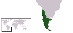
English: Map of the occupied and claimed territories of the Captaincy General of Chile, according to Chilean historiography.
IMPORTANT NOTE: Patagonian territories were never an effective part of the Captaincy, and according to 1570 Royal Decree the rights on the Eastern Patagonia belonged to the Rio de la Plata Province (Viceroyalty of Peru, later Viceroyalty of the Rio de la Plata), a situation not considered in Chilean historiography. Español: Mapa de los territorios ocupados y reclamados por la Capitanía General de Chile, según historiografía chilena. NOTA IMPORTANTE: los territorios patagónicos nunca formaron parte efectiva de la Capitanía, mientras que la Patagonia Oriental de acuerdo a la Real Cédula de 1570 correspondía de derecho a la Provincia del Río de la Plata (Virreinato del Perú, posteriormente Virreinato del Río de la Plata) situación no considerada en la historiografía chilena. |
||
| Source | Own work | ||
| Author | KRATK | ||
| Permission (Reusing this file) |
|
File history
Click on a date/time to view the file as it appeared at that time.
| Date/Time | Thumbnail | Dimensions | User | Comment | |
|---|---|---|---|---|---|
| current | 01:11, 15 November 2022 | | 250 × 115 (10 KB) | Janitoalevic | Con Cuyo |
| 22:35, 23 February 2009 |  | 250 × 115 (10 KB) | Dexxter | Reverted to version as of 23:15, 26 June 2005 | |
| 22:26, 7 October 2005 |  | 250 × 115 (7 KB) | B1mbo | Mapa aproximado de la ubicación y extensión de la Capitanía General de Chile | |
| 23:15, 26 June 2005 |  | 250 × 115 (10 KB) | B1mbo | Ubicación de la Capitanía General de Chile {{PD}} |
File usage
No pages on the English Wikipedia use this file (pages on other projects are not listed).