
File:Location Caricom.svg

Size of this PNG preview of this SVG file: 800 × 520 pixels. Other resolutions: 320 × 208 pixels | 640 × 416 pixels | 1,024 × 665 pixels | 1,280 × 831 pixels | 2,560 × 1,663 pixels | 1,484 × 964 pixels.
Original file (SVG file, nominally 1,484 × 964 pixels, file size: 1.67 MB)
| This is a file from the Wikimedia Commons. Information from its description page there is shown below. Commons is a freely licensed media file repository. You can help. |
| Description |
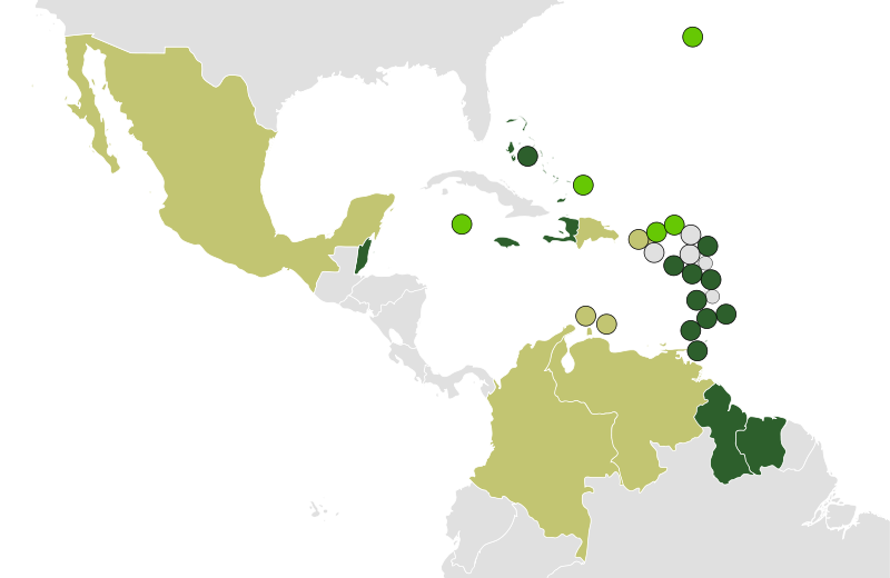
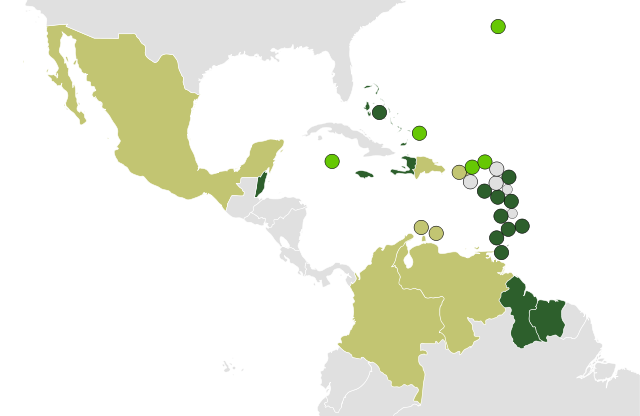
Deutsch: Karte der Mitgliedstaaten der Karibischen Gemeinschaft:
Mitgliedstaaten
Assoziierte Mitglieder
Beobachter |
||
| Date | |||
| Source | |||
| Author | Carport | ||
| Permission (Reusing this file) |
|
||
| Other versions |
 |
File history
Click on a date/time to view the file as it appeared at that time.
| Date/Time | Thumbnail | Dimensions | User | Comment | |
|---|---|---|---|---|---|
| current | 15:56, 6 July 2010 | | 1,484 × 964 (1.67 MB) | Carport | cropped |
| 15:27, 6 July 2010 |  | 1,485 × 1,064 (1.67 MB) | Carport | {{Information |Description={{en| Map of {{w|Caricom}} states: {{legend|#2d5f2c|full members}} {{legend|#66c804|associate members}} {{legend|#c2c572|observers}} }} {{de| Karte der Mitgliedstaaten der {{w|Karibische Gemeinschaft|Karibischen Gemeinschaft|de |
File usage
The following pages on the English Wikipedia use this file (pages on other projects are not listed):
Global file usage
The following other wikis use this file:
- Usage on ar.wikipedia.org
- Usage on ast.wikipedia.org
- Usage on bg.wikipedia.org
- Usage on da.wikipedia.org
- Usage on de.wikipedia.org
- Usage on el.wikipedia.org
- Usage on eo.wikipedia.org
- Usage on es.wikipedia.org
- Usage on eu.wikipedia.org
- Usage on fa.wikipedia.org
- Usage on fr.wikipedia.org
- Usage on fr.wikiversity.org
- Usage on gl.wikipedia.org
- Usage on he.wikipedia.org
- Usage on hr.wikipedia.org
- Usage on ht.wikipedia.org
- Usage on hu.wikipedia.org
- Usage on io.wikipedia.org
- Usage on it.wikipedia.org
- Usage on ka.wikipedia.org
- Usage on ko.wikipedia.org
- Usage on la.wikipedia.org
- Usage on lt.wikipedia.org
- Usage on mzn.wikipedia.org
- Usage on nl.wikinews.org
- Usage on nn.wikipedia.org
- Usage on pl.wikipedia.org
- Usage on pnb.wikipedia.org
- Usage on pt.wikipedia.org
- Usage on sr.wikipedia.org
- Usage on sv.wikipedia.org
- Usage on uk.wikipedia.org
- Usage on ur.wikipedia.org
- Usage on vi.wikipedia.org
View more global usage of this file.