
File:Ljungris July 2013.jpg

Size of this preview: 800 × 534 pixels. Other resolutions: 320 × 214 pixels | 640 × 427 pixels | 1,024 × 684 pixels | 1,280 × 854 pixels | 2,560 × 1,709 pixels | 6,016 × 4,016 pixels.
Original file (6,016 × 4,016 pixels, file size: 20.46 MB, MIME type: image/jpeg)
| This is a file from the Wikimedia Commons. Information from its description page there is shown below. Commons is a freely licensed media file repository. You can help. |
Summary
| Description |
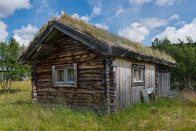
English: Building in Ljungris, Ljungdalen, Berg Municipality, Jämtland County. Ljungris is owned by the Sámi community and used especially for Reindeer calf marking in the summer.
|
| Date | |
| Source | Own work |
| Author | Arild Vågen |
| Camera location | | View this and other nearby images on: OpenStreetMap |
|---|
This file was made possible through the pool of technology at Wikimedia Sverige. |
Assessment
|

This image was selected as picture of the day on Wikimedia Commons for 15 February 2014. It was captioned as follows: English: Building in Ljungris, Ljungdalen, Berg Municipality, Jämtland County. Ljungris is owned by the Sámi community and used especially for Reindeer calf marking in the summer. Other languages:
Bosanski: Koliba u Ljungris, Ljungdalen, općina Berg, okrug Jämtland . Ljungris je u vlasništvu zajednice Sami i naročito se koristi tokom ljeta za obilježavanje teladi sobova. Čeština: Lovecká chata Ljungris, Ljungdalen, obec Berg, kraj Jämtland, Švédsko. Chata je vlastněna komunitou Sámi a používána především v létě pro značkování telat sobů. English: Building in Ljungris, Ljungdalen, Berg Municipality, Jämtland County. Ljungris is owned by the Sámi community and used especially for Reindeer calf marking in the summer. Italiano: Edificio in Ljungris, municipalità di Berg, Jämtland, Svezia. Ljungris è posseduto dalla comunità Sami e viene usato per la marchiatura dei piccoli di renna in estate. Magyar: Épület a svédországi Ljungrisban, Jämtland megyében. Ljungrist a számik a rénszarvasborjúk jelölésére használják nyáron Nederlands: Gebouw in Ljungris bij Ljungdalen in de gemeente Berg in de provincie Jämtlands län. Ljungris is eigendom van de Sámi-gemeenschap en wordt vooral gebruikt voor het merken van rendierkalveren in de zomer. Polski: Drewniana chata w osadzie Ljungris położonej w pobliżu Ljungdalen w gminie Berg, w szwedzkim okręgu administracyjnym Jämtland. Chata jest własnością społeczności lapońskiej i jest używana głównie w lecie podczas znakowania cieląt reniferów. 中文: 瑞典贝里市云格里斯的建筑。 |
Licensing
I, the copyright holder of this work, hereby publish it under the following license:
This file is licensed under the Creative Commons Attribution-Share Alike 3.0 Unported license.
- You are free:
- to share – to copy, distribute and transmit the work
- to remix – to adapt the work
- Under the following conditions:
- attribution – You must give appropriate credit, provide a link to the license, and indicate if changes were made. You may do so in any reasonable manner, but not in any way that suggests the licensor endorses you or your use.
- share alike – If you remix, transform, or build upon the material, you must distribute your contributions under the same or compatible license as the original.
File history
Click on a date/time to view the file as it appeared at that time.
| Date/Time | Thumbnail | Dimensions | User | Comment | |
|---|---|---|---|---|---|
| current | 09:25, 4 August 2013 | | 6,016 × 4,016 (20.46 MB) | ArildV | new version |
| 13:37, 29 July 2013 |  | 6,016 × 4,016 (20.7 MB) | ArildV | remove CA | |
| 08:01, 29 July 2013 |  | 6,016 × 4,016 (21.54 MB) | ArildV | User created page with UploadWizard |
File usage
The following pages on the English Wikipedia use this file (pages on other projects are not listed):
Global file usage
The following other wikis use this file:
- Usage on bcl.wiktionary.org
- Usage on be-tarask.wikipedia.org
- Usage on bn.wikipedia.org
- Usage on ca.wikipedia.org
- Usage on crh.wikipedia.org
- Usage on cs.wikipedia.org
- Usage on cv.wikipedia.org
- Usage on da.wikipedia.org
- Usage on de.wikipedia.org
- Usage on dsb.wikipedia.org
- Usage on el.wikipedia.org
- Usage on en.wikivoyage.org
- Usage on et.wikipedia.org
- Usage on fa.wikipedia.org
- سامی (اسکاندیناوی)
- بحث کاربر:Haji doliskani/بایگانی۱
- ویکیپدیا:گزیدن نگاره برگزیده/ژوئیه-۲۰۱۴
- ویکیپدیا:نگاره روز/ژانویه ۲۰۱۵
- ویکیپدیا:گزیدن نگاره برگزیده/Ljungris July 2013.jpg
- الگو:نر/2015-01-22
- الگو:نر محافظت شده/2015-01-22
- کاربر:Haji doliskani/نگاره
- ویکیپدیا:نگارههای برگزیده/جاها/معماری
- بخش بری
- Usage on hsb.wikipedia.org
- Usage on hu.wikipedia.org
- Usage on ia.wikipedia.org
- Usage on incubator.wikimedia.org
- Usage on ka.wikipedia.org
- Usage on ko.wikipedia.org
- Usage on krc.wikipedia.org
- Usage on lbe.wikipedia.org
- Usage on os.wikipedia.org
- Usage on pt.wikipedia.org
- Usage on ru.wikipedia.org
- Usage on ru.wikinews.org
- Usage on sah.wikipedia.org
- Usage on simple.wikipedia.org
- Usage on sl.wikipedia.org
- Usage on sq.wikipedia.org
- Usage on stq.wikipedia.org
- Usage on tt.wikipedia.org
- Usage on uk.wikipedia.org
- Usage on www.wikidata.org
- Usage on xal.wikipedia.org
View more global usage of this file.