
File:Littleworth Common, The eastern pond - geograph.org.uk - 1047532.jpg
No higher resolution available.
Littleworth_Common,_The_eastern_pond_-_geograph.org.uk_-_1047532.jpg (640 × 480 pixels, file size: 85 KB, MIME type: image/jpeg)
| This is a file from the Wikimedia Commons. Information from its description page there is shown below. Commons is a freely licensed media file repository. You can help. |
Summary
| Description |
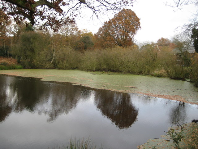
English: Littleworth Common: The eastern pond Littleworth Common is a heathland SSSI, and contains two large adjacent ponds of which this is the eastern of the pair. The common is one of the last recorded locations for the nationally rare starfruit Damasonium alisma. This is an annual plant, germinating on bare mud when pond water levels fall in late spring and summer. It cannot tolerate competition from other plants and has a very low seed output, but it actually thrives in the conditions provided by the trampling and puddling of cattle, and even geese, on the water's edge. This disturbance also stirs up the mud, brings seed to the surface and is an important factor in germination. Thus, one of the major reasons for its decline has been the discontinuance of grazing on heaths, resulting in an increase in the vegetation in and around heathland ponds. This has combined with a general lowering of the water table (through widespread land drainage and groundwater abstraction), to deprive the plant of the deep winter water and subsequent submergence, that it also requires. This information is from the English Nature website describing the SSSI, which also states that only one of the ponds is the location for starfruit, without specifying which, but that they also once supported another nationally rare plant, the small fleabane Pulicaria vulgaris, which has not been seen since 1949.
This pond is shown on the Ordnance Survey's map edition of 1876, although the other pond is not. For the other pond please see 1047512. |
| Date | |
| Source | From geograph.org.uk |
| Author | Nigel Cox |
| Attribution (required by the license) | Nigel Cox / Littleworth Common: The eastern pond / |
| Camera location | | View this and other nearby images on: OpenStreetMap |
|---|
_heading:67.00&language=en)
| Object location | | View this and other nearby images on: OpenStreetMap |
|---|
_heading:67.00&language=en)
Licensing

|
This image was taken from the Geograph project collection. See this photograph's page on the Geograph website for the photographer's contact details. The copyright on this image is owned by Nigel Cox and is licensed for reuse under the Creative Commons Attribution-ShareAlike 2.0 license.
|
This file is licensed under the Creative Commons Attribution-Share Alike 2.0 Generic license.
Attribution: Nigel Cox
- You are free:
- to share – to copy, distribute and transmit the work
- to remix – to adapt the work
- Under the following conditions:
- attribution – You must give appropriate credit, provide a link to the license, and indicate if changes were made. You may do so in any reasonable manner, but not in any way that suggests the licensor endorses you or your use.
- share alike – If you remix, transform, or build upon the material, you must distribute your contributions under the same or compatible license as the original.
File history
Click on a date/time to view the file as it appeared at that time.
| Date/Time | Thumbnail | Dimensions | User | Comment | |
|---|---|---|---|---|---|
| current | 21:42, 23 February 2011 | | 640 × 480 (85 KB) | GeographBot | == {{int:filedesc}} == {{Information |description={{en|1=Littleworth Common: The eastern pond Littleworth Common is a heathland SSSI, and contains two large adjacent ponds of which this is the eastern of the pair. The common is one of the last recorded lo |
File usage
The following pages on the English Wikipedia use this file (pages on other projects are not listed):
Global file usage
The following other wikis use this file:
- Usage on www.wikidata.org