
File:Little Comfort Church - geograph.org.uk - 416250.jpg
No higher resolution available.
Little_Comfort_Church_-_geograph.org.uk_-_416250.jpg (640 × 427 pixels, file size: 121 KB, MIME type: image/jpeg)
| This is a file from the Wikimedia Commons. Information from its description page there is shown below. Commons is a freely licensed media file repository. You can help. |
Summary
| Description |
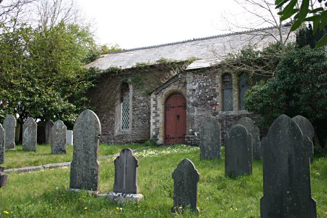
English: Little Comfort Church Everything about this is a mystery. I have not been able to discover any information about this church or the name. Little Comfort is a hamlet in the valley floor on the northern edge of Lezant Parish. This church is just off the main road and is a very small church with no spire. The gravestones in the churchyard range in date from the mid 19th century to the late 20th century. The church now appears disused and slowly decaying although there are still pews inside. |
| Date | |
| Source | From geograph.org.uk |
| Author | Tony Atkin |
| Attribution (required by the license) | Tony Atkin / Little Comfort Church / |
| Camera location | | View this and other nearby images on: OpenStreetMap |
|---|
_heading:67.00&language=en)
| Object location | | View this and other nearby images on: OpenStreetMap |
|---|
_heading:67.00&language=en)
Licensing

|
This image was taken from the Geograph project collection. See this photograph's page on the Geograph website for the photographer's contact details. The copyright on this image is owned by Tony Atkin and is licensed for reuse under the Creative Commons Attribution-ShareAlike 2.0 license.
|
This file is licensed under the Creative Commons Attribution-Share Alike 2.0 Generic license.
Attribution: Tony Atkin
- You are free:
- to share – to copy, distribute and transmit the work
- to remix – to adapt the work
- Under the following conditions:
- attribution – You must give appropriate credit, provide a link to the license, and indicate if changes were made. You may do so in any reasonable manner, but not in any way that suggests the licensor endorses you or your use.
- share alike – If you remix, transform, or build upon the material, you must distribute your contributions under the same or compatible license as the original.
File history
Click on a date/time to view the file as it appeared at that time.
| Date/Time | Thumbnail | Dimensions | User | Comment | |
|---|---|---|---|---|---|
| current | 01:28, 4 February 2011 | | 640 × 427 (121 KB) | GeographBot | == {{int:filedesc}} == {{Information |description={{en|1=Little Comfort Church Everything about this is a mystery. I have not been able to discover any information about this church or the name. Little Comfort is a hamlet in the valley floor on the north |
File usage
The following pages on the English Wikipedia use this file (pages on other projects are not listed):
Global file usage
The following other wikis use this file:
- Usage on eu.wikipedia.org
- Usage on www.wikidata.org