
File:Level IV ecoregions, Arkansas.pdf

Size of this JPG preview of this PDF file: 749 × 599 pixels. Other resolutions: 300 × 240 pixels | 600 × 480 pixels | 960 × 768 pixels | 1,280 × 1,024 pixels | 2,559 × 2,048 pixels | 6,750 × 5,402 pixels.
Original file (6,750 × 5,402 pixels, file size: 2.96 MB, MIME type: application/pdf)
| This is a file from the Wikimedia Commons. Information from its description page there is shown below. Commons is a freely licensed media file repository. You can help. |
Summary
| Description |
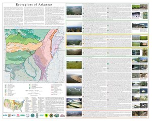
English: Poster of the ecoregions of Arkansas as defined by the USEPA |
| Date | |
| Source | Woods A.J., Foti, T.L., Chapman, S.S., Omernik, J.M., Wise, J.A., Murray, E.O., Prior, W.L., Pagan, J.B., Jr., Comstock, J.A., and Radford, M., 2004, Ecoregions of Arkansas (color poster with map, descriptive text, summary tables, and photographs): Reston, Virginia, U.S. Geological Survey (map scale 1:1,000,000). |
| Author | United States Environmental Protection Agency |
Licensing
This image (or other media) is a work of an Environmental Protection Agency employee, taken or made as part of that person's official duties. As works of the U.S. federal government, all EPA images are in the public domain.
|
||
File history
Click on a date/time to view the file as it appeared at that time.
| Date/Time | Thumbnail | Dimensions | User | Comment | |
|---|---|---|---|---|---|
| current | 15:18, 10 February 2018 |  | 6,750 × 5,402 (2.96 MB) | Brandonrush | User created page with UploadWizard |
File usage
No pages on the English Wikipedia use this file (pages on other projects are not listed).