
File:Layton railway station, Lancashire, geograph 5842530 by Nigel Thompson.jpg

Size of this preview: 800 × 600 pixels. Other resolutions: 320 × 240 pixels | 640 × 480 pixels | 1,024 × 768 pixels | 1,280 × 960 pixels | 1,600 × 1,200 pixels.
Original file (1,600 × 1,200 pixels, file size: 545 KB, MIME type: image/jpeg)
| This is a file from the Wikimedia Commons. Information from its description page there is shown below. Commons is a freely licensed media file repository. You can help. |
Summary
| Description |
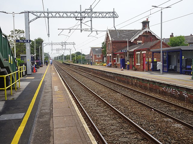
English: Layton railway station, Lancashire
Opened in 1846 (as Bispham) by the Preston & Wyre Joint Railway on its line from Preston to Blackpool Talbot Road (now Blackpool North), it was renamed Layton in 1932. View south west towards Blackpool, shortly after the line was electrified, and the footbridge and waiting shelter replaced. |
||
| Date | |||
| Source | geograph.org.uk | ||
| Author | Nigel Thompson | ||
| Permission (Reusing this file) |
This file is licensed under the Creative Commons Attribution-Share Alike 2.0 Generic license. Attribution: Nigel Thompson
|
||
| Attribution (required by the license) | Nigel Thompson / Layton railway station, Lancashire / | ||

| Camera location | | View this and other nearby images on: OpenStreetMap |
|---|
_region:GB-GBN_heading:225.00&language=en)
| Object location | | View this and other nearby images on: OpenStreetMap |
|---|
_region:GB-GBN_heading:225.00&language=en)
File history
Click on a date/time to view the file as it appeared at that time.
| Date/Time | Thumbnail | Dimensions | User | Comment | |
|---|---|---|---|---|---|
| current | 19:35, 6 March 2020 | | 1,600 × 1,200 (545 KB) | G-13114 | {{Information |description={{en|1=Layton railway station, Lancashire Opened in 1846 (as Bispham) by the Preston & Wyre Joint Railway on its line from Preston to Blackpool Talbot Road (now Blackpool North), it was renamed Layton in 1932. View south west towards Blackpool, shortly after the line was electrified, and the footbridge and waiting shelter replaced.}} |date=2018-07-13 |source= [https://www.geograph.org.uk geograph.org.uk] |author= Nigel Thompson |permission= {{Geograph|5842530|Nig... |
File usage
The following pages on the English Wikipedia use this file (pages on other projects are not listed):