
File:Laurie island map-en.svg

Size of this PNG preview of this SVG file: 800 × 420 pixels. Other resolutions: 320 × 168 pixels | 640 × 336 pixels | 1,024 × 537 pixels | 1,280 × 672 pixels | 2,560 × 1,343 pixels | 867 × 455 pixels.
Original file (SVG file, nominally 867 × 455 pixels, file size: 133 KB)
| This is a file from the Wikimedia Commons. Information from its description page there is shown below. Commons is a freely licensed media file repository. You can help. |
Summary
| Description |
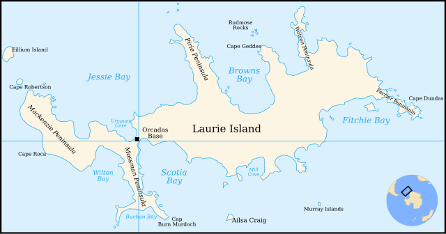
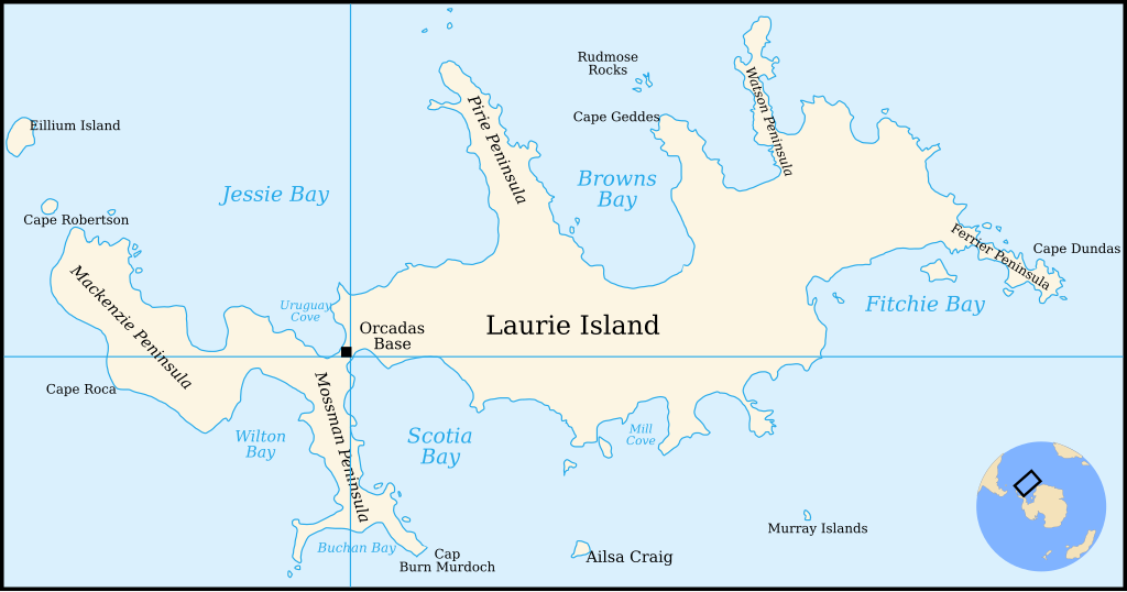
English: Map of Laurie Island, South Orkney Islands |
| Date | |
| Source | Translation of File:Laurie island map-fr.svg |
| Author | Original by Pinpin, translated to English by 4ing |
| Other versions | In French: File:Laurie island map-fr.svg |

|
This SVG file contains embedded text that can be translated into your language, using any capable SVG editor, text editor or the SVG Translate tool. For more information see: About translating SVG files. |
Licensing

|
Permission is granted to copy, distribute and/or modify this document under the terms of the GNU Free Documentation License, Version 1.2 or any later version published by the Free Software Foundation; with no Invariant Sections, no Front-Cover Texts, and no Back-Cover Texts. A copy of the license is included in the section entitled GNU Free Documentation License. |
| This file is licensed under the Creative Commons Attribution-Share Alike 3.0 Unported license. | ||
| Attribution: Pinpin and 4ing | ||
| ||
| This licensing tag was added to this file as part of the GFDL licensing update. |
File history
Click on a date/time to view the file as it appeared at that time.
| Date/Time | Thumbnail | Dimensions | User | Comment | |
|---|---|---|---|---|---|
| current | 21:29, 4 January 2011 | | 867 × 455 (133 KB) | 4ing | == {{int:filedesc}} == {{Information |Description={{en|1=Map of Laurie Island, South Orkney Islands}} |Source=Translation of File:Laurie island map-fr.svg |Author=Original by Pinpin, translated to English by 4ing |Date=2 |
File usage
The following pages on the English Wikipedia use this file (pages on other projects are not listed):
Global file usage
The following other wikis use this file:
- Usage on be.wikipedia.org
- Usage on bg.wikipedia.org
- Usage on ceb.wikipedia.org
- Usage on de.wikipedia.org
- Laurie Island
- Orcadas-Station
- Scotia Bay
- Mossman-Halbinsel
- Wilton Bay
- Mackenzie-Halbinsel
- Ailsa Craig (Südliche Orkneyinseln)
- Kap Anderson
- Mill Cove
- Valette Island
- Baldred Rock
- Graptolite Island
- Fitchie Bay
- Ferrier-Halbinsel
- Kap Dundas
- Kap Geddes
- Browns Bay (Laurie Island)
- Pirie-Halbinsel
- Rudmose Rocks
- Watson-Halbinsel
- Kap Mabel
- Jessie Bay
- Marr Bay
- Kap Robertson
- Kap Valavielle
- Buchan Bay
- Uruguay Cove
- Usage on eo.wikipedia.org
- Usage on es.wikipedia.org
- Usage on fi.wikipedia.org
- Usage on fr.wikipedia.org
- Usage on he.wikipedia.org
- Usage on ja.wikipedia.org
- Usage on ka.wikipedia.org
- Usage on lld.wikipedia.org
- Usage on mk.wikipedia.org
- Usage on nn.wikipedia.org
View more global usage of this file.