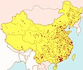
File:Laogai Map.jpg

Size of this preview: 714 × 600 pixels. Other resolutions: 286 × 240 pixels | 572 × 480 pixels | 1,000 × 840 pixels.
Original file (1,000 × 840 pixels, file size: 335 KB, MIME type: image/jpeg)
File history
Click on a date/time to view the file as it appeared at that time.
| Date/Time | Thumbnail | Dimensions | User | Comment | |
|---|---|---|---|---|---|
| current | 09:04, 30 October 2020 |  | 1,000 × 840 (335 KB) | Claude Zygiel | Added claims from Ahmetlii's idea |
| 13:17, 30 August 2020 |  | 1,000 × 840 (332 KB) | Claude Zygiel | Better version | |
| 02:39, 26 July 2020 |  | 1,000 × 840 (168 KB) | Geographyinitiative | Reverted to version as of 17:48, 11 December 2018 (UTC) | |
| 16:40, 26 February 2020 |  | 1,000 × 840 (332 KB) | Julieta39 | More visible by contrast. Aksai Chin chinese (de facto). Other communist countries in pink. Taiwan in green (as a sample fact: we don't debate about the status of this island). Seas in blue. | |
| 17:48, 11 December 2018 |  | 1,000 × 840 (168 KB) | Khu'hamgaba Kitap | The point of this map is to show former Laogai Facilities in China, not to spur on a Taiwan independence debate - Simply removing the disputed island would be much better for the sake of the article than adding a note about PRC vs ROC rule, along with the line "where all ''laogai'' camps are". The reader should be able to deduce that themself rather than being told so | |
| 01:55, 28 December 2014 |  | 800 × 672 (134 KB) | Nguyen1310 | Regions under the jurisdiction of the communist People's Republic of China [PRC] and the free Republic of China [ROC] are denoted with different colors. China is technically not "one country", but under 2 separate political entities. | |
| 21:27, 27 July 2006 |  | 1,000 × 840 (187 KB) | Marco L | {{Information |Description=map of laogai in China |Source=own work |Date=27/07/06 |Author=Marco L |Permission= |other_versions= }} |
File usage
The following pages on the English Wikipedia use this file (pages on other projects are not listed):
Global file usage
The following other wikis use this file:
- Usage on be-tarask.wikipedia.org
- Usage on ca.wikipedia.org
- Usage on de.wikipedia.org
- Usage on el.wikipedia.org
- Usage on es.wikipedia.org
- Usage on fr.wikipedia.org
- Usage on id.wikipedia.org
- Usage on it.wikipedia.org
- Usage on ja.wikipedia.org
- Usage on mk.wikipedia.org
- Usage on nl.wikipedia.org
- Usage on no.wikipedia.org
- Usage on pl.wikipedia.org
- Usage on pt.wikipedia.org
- Usage on ro.wikipedia.org
- Usage on ru.wikipedia.org
- Usage on sc.wikipedia.org
- Usage on sl.wikipedia.org
- Usage on sv.wikipedia.org
- Usage on www.wikidata.org

