
File:Lama guanicoe range map.png
No higher resolution available.
Lama_guanicoe_range_map.png (431 × 588 pixels, file size: 20 KB, MIME type: image/png)
| This is a file from the Wikimedia Commons. Information from its description page there is shown below. Commons is a freely licensed media file repository. You can help. |
Hmbvb
Summary
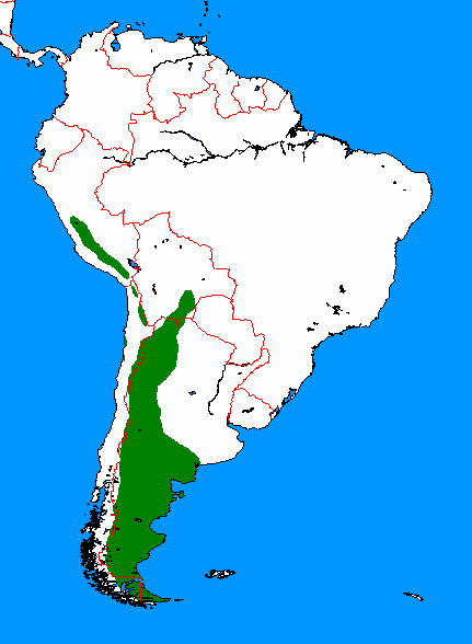
| Description |
English: Range map for Guanaco (Lama guanicoe), made by me with help of www.aquarius.geomar.de, Map depending on the range map at IUCN red list. |
| Date | |
| Source | Own work |
| Author | Udo Schröter |
Licensing
I, the copyright holder of this work, hereby publish it under the following licenses:
This file is licensed under the Creative Commons Attribution-Share Alike 3.0 Unported, 2.5 Generic, 2.0 Generic and 1.0 Generic license.
- You are free:
- to share – to copy, distribute and transmit the work
- to remix – to adapt the work
- Under the following conditions:
- attribution – You must give appropriate credit, provide a link to the license, and indicate if changes were made. You may do so in any reasonable manner, but not in any way that suggests the licensor endorses you or your use.
- share alike – If you remix, transform, or build upon the material, you must distribute your contributions under the same or compatible license as the original.

|
Permission is granted to copy, distribute and/or modify this document under the terms of the GNU Free Documentation License, Version 1.2 or any later version published by the Free Software Foundation; with no Invariant Sections, no Front-Cover Texts, and no Back-Cover Texts. A copy of the license is included in the section entitled GNU Free Documentation License. |
You may select the license of your choice.
File history
Click on a date/time to view the file as it appeared at that time.
| Date/Time | Thumbnail | Dimensions | User | Comment | |
|---|---|---|---|---|---|
| current | 11:07, 2 May 2013 | | 431 × 588 (20 KB) | Termininja | no frame |
| 16:17, 9 May 2010 |  | 448 × 605 (18 KB) | Nordelch | {{Information |Description={{en|1=Range map for Guanaco (''Lama guanicoe''), made by me with help of [http://www.aquarius.geomar.de/omc_intro.html www.aquarius.geomar.de], Map depending on the [http://www.iucnredlist.org/apps/redlist/details/11186 ran |
File usage
The following pages on the English Wikipedia use this file (pages on other projects are not listed):
Global file usage
The following other wikis use this file:
- Usage on an.wikipedia.org
- Usage on ar.wikipedia.org
- Usage on avk.wikipedia.org
- Usage on azb.wikipedia.org
- Usage on be.wikipedia.org
- Usage on ca.wikipedia.org
- Usage on de.wikipedia.org
- Usage on es.wikipedia.org
- Usage on fr.wikipedia.org
- Usage on gd.wikipedia.org
- Usage on gn.wikipedia.org
- Usage on hu.wikipedia.org
- Usage on ka.wikipedia.org
- Usage on la.wikipedia.org
- Usage on ml.wikipedia.org
- Usage on nl.wikipedia.org
- Usage on no.wikipedia.org
- Usage on pl.wikipedia.org
- Usage on ru.wikipedia.org
- Usage on sh.wikipedia.org
- Usage on sq.wikipedia.org
- Usage on sr.wikipedia.org
- Usage on sv.wikipedia.org
- Usage on uk.wikipedia.org
- Usage on vi.wikipedia.org
- Usage on zh.wikipedia.org