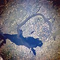
File:Lake sakakawea.jpg

Size of this preview: 607 × 600 pixels. Other resolutions: 243 × 240 pixels | 486 × 480 pixels | 778 × 768 pixels | 1,037 × 1,024 pixels | 2,073 × 2,048 pixels | 3,904 × 3,856 pixels.
Original file (3,904 × 3,856 pixels, file size: 6.91 MB, MIME type: image/jpeg)
File history
Click on a date/time to view the file as it appeared at that time.
| Date/Time | Thumbnail | Dimensions | User | Comment | |
|---|---|---|---|---|---|
| current | 18:31, 27 February 2012 |  | 3,904 × 3,856 (6.91 MB) | Ras67 | high resolution |
| 13:41, 4 August 2007 |  | 639 × 632 (192 KB) | Matthiasb | {{Information |Description=Van Hook Arm of Lake Sakakawea, North Dakota, United States - July 1996 The image description can be found [http://eol.jsc.nasa.gov/sseop/EFS/photoinfo.pl?PHOTO=NM21-765-97 here]. North is to the right side of the image.[http: |
File usage
The following pages on the English Wikipedia use this file (pages on other projects are not listed):
Global file usage
The following other wikis use this file:
- Usage on azb.wikipedia.org
- Usage on ceb.wikipedia.org
- Usage on de.wikipedia.org
- Usage on es.wikipedia.org
- Usage on fa.wikipedia.org
- Usage on fr.wikipedia.org
- Usage on it.wikipedia.org
- Usage on ru.wikipedia.org
- Usage on sr.wikipedia.org
- Usage on te.wikipedia.org
- Usage on www.wikidata.org
- Usage on zh.wikipedia.org


