
File:Lake Shore Drive.JPG
Lake_Shore_Drive.JPG (300 × 200 pixels, file size: 16 KB, MIME type: image/jpeg)
Summary[edit]
| Description |
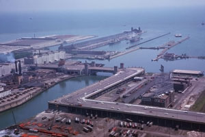
Mouth of Chicago River and Navy Pier from the top of the Prudential Building |
|---|---|
| Source |
Cushman, C. W. Indiana University Archives, Charles W. Cushman Photograph Collection. (1963, May 26). Indiana University Archives ID P12880. Retrieved August 10, 2007, from http://webapp1.dlib.indiana.edu/cushman/results/detail.do?query=state%3A%22Illinois%22+AND+year%3A%221963%22&page=2&pagesize=20&display=thumbcap&action=browse&pnum=P12880 |
| Date | |
| Author |
Charles W. Cushman |
| Permission (Reusing this file) |
Copyrighted with permission to use in the Chicago Spire article.
|
Licensing[edit]
 | This work is copyrighted (or assumed to be copyrighted) and unlicensed. It does not fall into one of the blanket acceptable non-free content categories listed at Wikipedia:Non-free content § Images or Wikipedia:Non-free content § Audio clips, and it is not covered by a more specific non-free content license listed at Category:Wikipedia non-free file copyright templates. However, it is believed that the use of this work:
qualifies as fair use under United States copyright law. Any other uses of this image, on Wikipedia or elsewhere, may be copyright infringement. See Wikipedia:Non-free content and Wikipedia:Copyrights. |
| In addition to the non-free use assertion shown on this page, the copyright holder has granted permission for this image to be used in Wikipedia. This permission does not extend to third parties. This tag must be used in conjunction with another non-free use image tag. If no other tag is present on this page, and this image was uploaded after May 19, 2005, please speedily delete this image or tag it with {{db-f3}}. To the uploader: Please add a detailed non-free use rationale for each use, as well as the source of the work and copyright information. |
Source[edit]
Charles W. Cushman Photograph Collection at the Indiana University Archives / Digital Library Program (Image, Source's conditions of use and copyright information & reproduction requests)
Fair use rationale[edit]
The following addresses general concerns regarding fair use policies of images in Wikipedia.
- Purpose and character of the use: Educational use: illustrates a scene from the history of Chicago, Illinois.
- Nature of the copyrighted work: historic photograph from 1963.
- Amount used: The image is cropped slightly. The current resolution is required to see an accurate depiction of the site of the Chicago Spire and DuSable Park prior to the demolition of the factory.
- Effect of the use on the potential market or value of the image: The resolution is not sufficient enough for a serious reproduction of the image in a book or other published source. The image, in fact, may draw interest to the University's collection. A link is included above for that purpose.
Further considerations:
- The probability that this image could be replaced by a free image is very low because of its historical significance. If a free image is found that can replace this image, this image should be deleted and the free image should be used instead.
- The curator of photographs at Indiana University has authorized this image use on Wikipedia.
| Description |
This is an aerial photo of the former elevated "S-Curve" on Lake Shore Drive, looking northeast. The curve no longer exists, and little remains of the structure. |
|---|---|
| Source |
Charles W. Cushman Photograph Collection, taken May 26, 1963 from the top of the Prudential Building. |
| Article | |
| Portion used |
This is almost the entire image, since it is important to show not only the curves themselves but the approaches and surrounding areas. |
| Low resolution? |
The resolution is high enough to see some of the major details of the roadway, but is low enough that the collection offers it freely. |
| Purpose of use |
To show the "S-Curve" on Lake Shore Drive in a way that text cannot; seeing the image shows how sharp the curves really were on a road that was essentially a freeway. It also shows the former industrial uses of the area that is now being redeveloped as Lakeshore East, and gives a feeling for what drivers on Lake Shore Drive were passing through. |
| Replaceable? |
The current alignment opened in 1986 and the old structure was torn down. There are no known freely-licensed photographs of the structure taken at such an angle that both the configuration and the elevated nature can be seen. A straight-down aerial photograph would not serve the same purpose. |
| Fair useFair use of copyrighted material in the context of Lake Shore Drive//en.wikipedia.org/wiki/File:Lake_Shore_Drive.JPGtrue | |
| Description |
This is an aerial photo of the former elevated "S-Curve" on Lake Shore Drive, looking northeast. The curve no longer exists, and little remains of the structure. |
|---|---|
| Source |
Charles W. Cushman Photograph Collection, taken May 26, 1963 from the top of the Prudential Building. |
| Article | |
| Portion used |
This is almost the entire image, since it is important to show not only the curves themselves but the approaches and surrounding areas. |
| Low resolution? |
The resolution is high enough to see some of the major details of the roadway, but is low enough that the collection offers it freely. |
| Purpose of use |
To show the "S-Curve" on Lake Shore Drive in a way that text cannot; seeing the image shows how sharp the curves really were on a road that was essentially a freeway. It also shows the former industrial uses of the area that is now being redeveloped as Lakeshore East, and gives a feeling for what drivers on Lake Shore Drive were passing through. |
| Replaceable? |
The current alignment opened in 1986 and the old structure was torn down. There are no known freely-licensed photographs of the structure taken at such an angle that both the configuration and the elevated nature can be seen. A straight-down aerial photograph would not serve the same purpose. |
| Fair useFair use of copyrighted material in the context of Lakeshore East//en.wikipedia.org/wiki/File:Lake_Shore_Drive.JPGtrue | |
File history
Click on a date/time to view the file as it appeared at that time.
| Date/Time | Thumbnail | Dimensions | User | Comment | |
|---|---|---|---|---|---|
| current | 06:46, 29 November 2008 | | 300 × 200 (16 KB) | Melesse (talk | contribs) | {{Non-free reduced|~~~~~}} |
You cannot overwrite this file.