
File:Lake Del Valle, Near Livermore, California (10753667465).jpg

Original file (4,000 × 3,000 pixels, file size: 2.53 MB, MIME type: image/jpeg)
| This is a file from the Wikimedia Commons. Information from its description page there is shown below. Commons is a freely licensed media file repository. You can help. |
.jpg)
Summary
| Description |
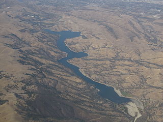
Lake Del Valle is an artificial lake located 10 miles (16 km) southeast of Livermore, California on Arroyo del Valle (Spanish for "creek of the valley") in Del Valle Regional Park. The lake is formed by Del Valle Dam, completed in 1968. The lake and dam are part of the California State Water Project, as part of the South Bay Aqueduct. The lake serves in part as off-stream storage for the South Bay Aqueduct. The capacity of the lake is 77,000 acre feet (95,000,000 m3), however, the lake has a flood storage of 25,000 to 40,000 acre feet (31,000,000 to 49,000,000 m3). Thus normally stores 37,000 to 52,000 acre feet (46,000,000 to 64,000,000 m3). The lake is a popular destination for hikers, bikers and boaters. The Hetch Hetchy Aqueduct passes below the lake, but does not connect to it. en.wikipedia.org/wiki/Lake_Del_Valle en.wikipedia.org/wiki/Wikipedia:Text_of_Creative_Commons_... |
| Date | |
| Source | Lake Del Valle, Near Livermore, California |
| Author | Ken Lund from Reno, Nevada, USA |
| Camera location | | View this and other nearby images on: OpenStreetMap |
|---|
.jpg¶ms=037.598141_N_-121.722153_E_globe:Earth_type:camera_source:Flickr_&language=en)
Licensing
- You are free:
- to share – to copy, distribute and transmit the work
- to remix – to adapt the work
- Under the following conditions:
- attribution – You must give appropriate credit, provide a link to the license, and indicate if changes were made. You may do so in any reasonable manner, but not in any way that suggests the licensor endorses you or your use.
- share alike – If you remix, transform, or build upon the material, you must distribute your contributions under the same or compatible license as the original.
| This image was originally posted to Flickr by Ken Lund at https://flickr.com/photos/75683070@N00/10753667465. It was reviewed on 4 December 2015 by FlickreviewR and was confirmed to be licensed under the terms of the cc-by-sa-2.0. |
File history
Click on a date/time to view the file as it appeared at that time.
| Date/Time | Thumbnail | Dimensions | User | Comment | |
|---|---|---|---|---|---|
| current | 00:56, 4 December 2015 | | 4,000 × 3,000 (2.53 MB) | INeverCry | Transferred from Flickr via Flickr2Commons |
File usage
Global file usage
The following other wikis use this file:
- Usage on en.wikivoyage.org
- Usage on it.wikivoyage.org
- Usage on www.wikidata.org
.jpg)