
File:Lagekarte Grafschaft Henneberg um 1350.png

Size of this preview: 552 × 600 pixels. Other resolutions: 221 × 240 pixels | 442 × 480 pixels | 706 × 767 pixels.
Original file (706 × 767 pixels, file size: 123 KB, MIME type: image/png)
| This is a file from the Wikimedia Commons. Information from its description page there is shown below. Commons is a freely licensed media file repository. You can help. |
Summary
| Description |
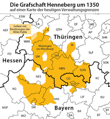
Deutsch: Lagekarte der Grafschaft Henneberg um 1350. Hinterlegt die heutigen Kreis- und Ländergrenzen. |
| Date | see file history |
| Source | Own work using: |
| Author | Maximilian Dörrbecker (Chumwa) |
| Permission (Reusing this file) |
I, the copyright holder of this work, hereby publish it under the following license: This file is licensed under the Creative Commons Attribution-Share Alike 2.5 Generic license.
Sie dürfen das Bild zu den folgenden Bedingungen nutzen:
|
File history
Click on a date/time to view the file as it appeared at that time.
| Date/Time | Thumbnail | Dimensions | User | Comment | |
|---|---|---|---|---|---|
| current | 17:56, 23 July 2018 | | 706 × 767 (123 KB) | Chumwa | corr |
| 06:03, 13 November 2017 |  | 706 × 767 (124 KB) | Chumwa | ||
| 19:51, 9 November 2017 |  | 751 × 767 (131 KB) | Chumwa | == {{int:filedesc}} == {{Information | Description = {{de|1=Lagekarte der Grafschaft Henneberg um 1350. Hinterlegt die heutigen Kreis- und Ländergrenzen.}} |Source = {{own using}} |Date = see file history |Author = [[:de:User:C... |
File usage
The following pages on the English Wikipedia use this file (pages on other projects are not listed):
Global file usage
The following other wikis use this file:
- Usage on arz.wikipedia.org
- Usage on bg.wikipedia.org
- Usage on cs.wikipedia.org
- Usage on de.wikipedia.org
- Usage on eo.wikipedia.org
- Usage on fr.wikipedia.org
- Usage on nl.wikipedia.org
- Usage on ru.wikipedia.org