
File:Kowloon clock tower. HK (16047633422).jpg

Original file (2,271 × 1,596 pixels, file size: 3.89 MB, MIME type: image/jpeg)
| This is a file from the Wikimedia Commons. Information from its description page there is shown below. Commons is a freely licensed media file repository. You can help. |
.jpg)
Summary
| Description |
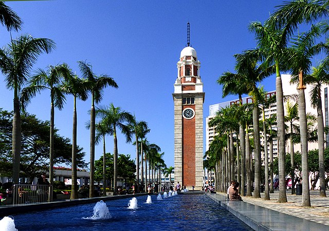
Standing 44-metres tall, the old Clock Tower was erected in 1915 as part of the Kowloon–Canton Railway terminus. The once-bustling station is long gone, but this red brick and granite tower, now preserved as a Declared Monument, survives as an elegant reminder of the Age of Steam. It has also been a memorable landmark for the millions of Chinese immigrants who passed through the terminus to begin new lives not just in Hong Kong, but in other parts of the world via the city’s harbour. A history of the Clock Tower 1910 The Kowloon-Canton Railway line is opened. 1913 Foundations are laid for the terminus in Tsim Sha Tsui. 1915 The station and its clock tower are almost complete but the delivery of fittings and fixtures from Britain are delayed because of the First World War. 1916 Terminus station is completed and officially opened. However, the clock was not installed in the tower because of concerns about costs. Photographs from this era show the tower without a clock face. 1919 Funds to complete the clock tower were eventually raised. The bell and electric clock arrive in Hong Kong but installation was further postponed until necessary drawings and instructions from the manufacturer were obtained. 1921 After years of delays, the clock begins operating. 1970s A new terminus station is opened in Hung Hom and the old station is demolished with the execption of the Clock Tower. 1990s The Clock Tower is listed as a Declared Monument. |
| Date | |
| Source | Kowloon clock tower. HK |
| Author | Bernard Spragg. NZ from Christchurch, New Zealand |
| Camera location | | View this and other nearby images on: OpenStreetMap |
|---|
.jpg¶ms=022.294079_N_0114.169321_E_globe:Earth_type:camera_source:Flickr_&language=en)
Licensing
| This file is made available under the Creative Commons CC0 1.0 Universal Public Domain Dedication. | |
| The person who associated a work with this deed has dedicated the work to the public domain by waiving all of their rights to the work worldwide under copyright law, including all related and neighboring rights, to the extent allowed by law. You can copy, modify, distribute and perform the work, even for commercial purposes, all without asking permission.
|
| This image was originally posted to Flickr by Bernard Spragg at https://flickr.com/photos/88123769@N02/16047633422 (archive). It was reviewed on 4 July 2018 by FlickreviewR 2 and was confirmed to be licensed under the terms of the cc-zero. |
File history
Click on a date/time to view the file as it appeared at that time.
| Date/Time | Thumbnail | Dimensions | User | Comment | |
|---|---|---|---|---|---|
| current | 15:31, 4 July 2018 | | 2,271 × 1,596 (3.89 MB) | Thesupermat2 | Transferred from Flickr via #flickr2commons |
File usage
Global file usage
The following other wikis use this file:
- Usage on zh.wikipedia.org
.jpg)