
File:Korea map 1939.svg

Size of this PNG preview of this SVG file: 634 × 387 pixels. Other resolutions: 320 × 195 pixels | 640 × 391 pixels | 1,024 × 625 pixels | 1,280 × 781 pixels | 2,560 × 1,563 pixels.
Original file (SVG file, nominally 634 × 387 pixels, file size: 2.23 MB)
| This is a file from the Wikimedia Commons. Information from its description page there is shown below. Commons is a freely licensed media file repository. You can help. |
Summary
| Description |
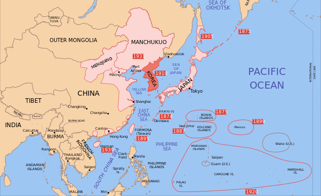
English: Map of 1939, showing Colonial Korea (highlighted), and other Japanese territories and colonies, under rule of the Empire of Japan. |
| Date | |
| Source | Own work |
| Author | Emok |
| Other versions |
|


Licensing
I, the copyright holder of this work, hereby publish it under the following licenses:
This file is licensed under the Creative Commons Attribution-Share Alike 3.0 Unported license.
- You are free:
- to share – to copy, distribute and transmit the work
- to remix – to adapt the work
- Under the following conditions:
- attribution – You must give appropriate credit, provide a link to the license, and indicate if changes were made. You may do so in any reasonable manner, but not in any way that suggests the licensor endorses you or your use.
- share alike – If you remix, transform, or build upon the material, you must distribute your contributions under the same or compatible license as the original.

|
Permission is granted to copy, distribute and/or modify this document under the terms of the GNU Free Documentation License, Version 1.2 or any later version published by the Free Software Foundation; with no Invariant Sections, no Front-Cover Texts, and no Back-Cover Texts. A copy of the license is included in the section entitled GNU Free Documentation License. |
You may select the license of your choice.
File history
Click on a date/time to view the file as it appeared at that time.
| Date/Time | Thumbnail | Dimensions | User | Comment | |
|---|---|---|---|---|---|
| current | 14:42, 16 September 2023 | | 634 × 387 (2.23 MB) | KajenCAT | File uploaded using svgtranslate tool (https://svgtranslate.toolforge.org/). Added translation for ca. |
| 15:18, 2 June 2023 |  | 634 × 387 (2.2 MB) | SmallJarsWithGreenLabels | sp again | |
| 23:41, 1 June 2023 |  | 634 × 387 (2.2 MB) | SmallJarsWithGreenLabels | trying again | |
| 23:39, 1 June 2023 |  | 634 × 387 (2.19 MB) | SmallJarsWithGreenLabels | saipan per user:Geographyinitiative | |
| 23:21, 1 June 2023 |  | 634 × 387 (2.19 MB) | SmallJarsWithGreenLabels | sp | |
| 01:32, 27 August 2010 |  | 634 × 387 (2.21 MB) | Splittist | No reason for Xinjiang to have separate borders from China | |
| 23:37, 30 May 2009 |  | 634 × 387 (2.21 MB) | SelfQ~commonswiki | Cluttering and removal of key elements is not acceptable. If you want a Chineese version please upload on under its own file name. | |
| 10:44, 17 May 2009 |  | 1,300 × 1,201 (864 KB) | Xiamipi | 增加中文说明 | |
| 22:33, 2 December 2008 |  | 634 × 387 (2.21 MB) | Valentim | Reverted to version as of 15:20, 30 October 2008. Dear 쿠도군 (now WhiteNight7), I gave you an explanation, why your changes are not appropriable. Please stop reverting. Thank you. | |
| 02:57, 30 November 2008 |  | 634 × 387 (2.21 MB) | WhiteNight7 |
File usage
The following pages on the English Wikipedia use this file (pages on other projects are not listed):
Global file usage
The following other wikis use this file:
- Usage on ar.wikipedia.org
- Usage on bcl.wikipedia.org
- Usage on bg.wikipedia.org
- Usage on ca.wikipedia.org
- Usage on cs.wikipedia.org
- Usage on eo.wikipedia.org
- Usage on fr.wikipedia.org
- Usage on it.wikipedia.org
- Usage on lt.wikipedia.org
- Usage on nl.wikipedia.org
- Usage on pt.wikipedia.org
- Usage on zh-yue.wikipedia.org