
File:Kokoda trail NE at top.jpg
Size of this preview: 208 × 598 pixels. Other resolution: 212 × 610 pixels.
Original file (212 × 610 pixels, file size: 27 KB, MIME type: image/jpeg)
| This is a file from the Wikimedia Commons. Information from its description page there is shown below. Commons is a freely licensed media file repository. You can help. |
Summary
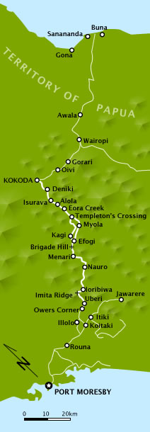
| Description | A map of the Kokoda Trail/Track as it was in 1942. It has been rotated so the trail which runs roughly NE from Port Moresby runs up and down the page. |
| Date | |
| Source |
Own work
|
| Author | Chris Rees User:SpoolWhippets |
| Permission (Reusing this file) |
This file is licensed under the Creative Commons Attribution-Share Alike 3.0 Unported license.
|
File history
Click on a date/time to view the file as it appeared at that time.
| Date/Time | Thumbnail | Dimensions | User | Comment | |
|---|---|---|---|---|---|
| current | 13:04, 29 March 2010 | 212 × 610 (27 KB) | SpoolWhippets | changed colours to match other PNG campaign maps | |
| 22:50, 8 March 2010 | 502 × 1,532 (87 KB) | SpoolWhippets | corrected rotation of Jawarere added Coral Sea, Solomon Sea added Brigade Hill altered appearance of marker for Imita Ridge and Port Moresby added shading to indicate extent of Imita Ridge (as shown on other Kokoda maps) | ||
| 06:50, 8 March 2010 | 502 × 1,532 (82 KB) | SpoolWhippets | {{Information |Description={{en|1=A map of the Kokoda Trail/Track as it was in 1942. It has been rotated so the trail which runs roughly NE from Port Moresby runs up and down the page.}} |Source={{own}} |Author=SpoolWhippets |Date=2 |
File usage
The following pages on the English Wikipedia use this file (pages on other projects are not listed):
- 6th Division (Australia)
- Arnold Potts
- Battle of Isurava
- Chaforce
- First Battle of Eora Creek–Templeton's Crossing
- Herbert Thomson Kienzle
- Invasion of Buna–Gona
- Kokoda Track
- Kokoda Track campaign
- Myola
- Papuan Infantry Battalion
- Second Battle of Eora Creek–Templeton's Crossing
- Templeton's Crossing
- Wairopi
Global file usage
The following other wikis use this file:
- Usage on de.wikipedia.org
- Usage on de.wikivoyage.org
- Usage on fa.wikipedia.org
- Usage on hu.wikipedia.org
- Usage on pl.wikipedia.org
- Usage on vi.wikipedia.org