
File:Knoviz CZ from S116.jpg

Size of this preview: 800 × 600 pixels. Other resolutions: 320 × 240 pixels | 640 × 480 pixels | 1,024 × 768 pixels | 1,280 × 960 pixels | 1,984 × 1,488 pixels.
Original file (1,984 × 1,488 pixels, file size: 696 KB, MIME type: image/jpeg)
| This is a file from the Wikimedia Commons. Information from its description page there is shown below. Commons is a freely licensed media file repository. You can help. |
| Description |
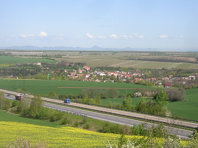
Čeština: Knovíz, okres Kladno. Celkový pohled na obec v údolí Knovízského (Svatojiřského) potoka od jihu, z pole na horní hraně údolí. V popředí rychlostní dilnice R7, při levém okraji obce jasnou zelení vyniká báň věže kostela Všech Svatých. Hnědé plochy, prostírající se za vsí, jsou rozsáhlé jabloňové sady mezi Knovízí a Blahoticemi. Tlustý pruh stromoví, vybíhající od pravého okraje a pokračující tenčí zhruba vodorovnou linií přes obraz vlevo, naznačuje průběh železniční trati 110 mezi stanicí Podlešín a zastávkou Slaný předměstí. Na obzoru patrné zhruba 40 km vzdálené pásmo Českého středohoří s nejvyšší horou Milešovkou uprostřed. Fotografie z nadhledu krajinu poněkud zplošťuje, takže se údolí jeví mělčí, ve skutečnosti výškový rozdíl mezi stanovištěm pozorovatele a středem obce činí zhruba 90 metrů.
English: Village of Knovíz, Kladno District, Czech Republic, as seen from the south. In the foregrund Expressway R7 from Prague to Slaný, on the left edge of the village green tower of All Saints church. Large apple orchards covering most of the area beyond the village appear in brown colour. On the horizon mountains of the České středohoří in distance of about 40 km. |
||
| Date | |||
| Source | Own work | ||
| Author | User:Miaow Miaow | ||
| Permission (Reusing this file) |
|
| Camera location | | View this and other nearby images on: OpenStreetMap |
|---|
File history
Click on a date/time to view the file as it appeared at that time.
| Date/Time | Thumbnail | Dimensions | User | Comment | |
|---|---|---|---|---|---|
| current | 22:40, 2 June 2008 | | 1,984 × 1,488 (696 KB) | Miaow Miaow | {{Information |Description= {{cs|'''Knovíz''', okres Kladno. Celkový pohled na obec v údolí Knovízského (Svatojiřského) potoka od jihu, z pole na horní hraně údolí. V popředí [[:cs:Rychlostní siln |
File usage
The following pages on the English Wikipedia use this file (pages on other projects are not listed):
Global file usage
The following other wikis use this file:
- Usage on ceb.wikipedia.org
- Usage on ce.wikipedia.org
- Usage on cs.wikipedia.org
- Usage on de.wikipedia.org
- Usage on es.wikipedia.org
- Usage on eu.wikipedia.org
- Usage on fa.wikipedia.org
- Usage on fr.wikipedia.org
- Usage on hu.wikipedia.org
- Usage on it.wikipedia.org
- Usage on ka.wikipedia.org
- Usage on lmo.wikipedia.org
- Usage on nl.wikipedia.org
- Usage on pl.wikipedia.org
- Usage on pt.wikipedia.org
- Usage on sr.wikipedia.org
- Usage on sv.wikipedia.org
- Usage on tt.wikipedia.org
- Usage on vi.wikipedia.org
- Usage on www.wikidata.org
- Usage on zh-min-nan.wikipedia.org