
File:Kirkby-in-Ashfield station geograph-3725308-by-Ben-Brooksbank.jpg

Size of this preview: 800 × 488 pixels. Other resolutions: 320 × 195 pixels | 640 × 391 pixels | 1,024 × 625 pixels | 1,280 × 781 pixels | 2,351 × 1,435 pixels.
Original file (2,351 × 1,435 pixels, file size: 2.88 MB, MIME type: image/jpeg)
| This is a file from the Wikimedia Commons. Information from its description page there is shown below. Commons is a freely licensed media file repository. You can help. |
Summary
| Description |
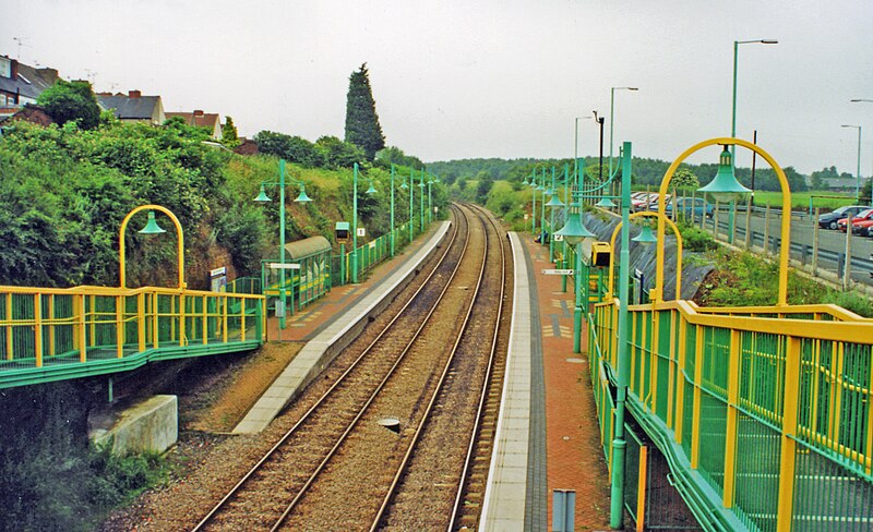
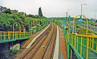
English: Kirkby-in-Ashfield new station, Robin Hood new line, 2000. View northward, towards Mansfield, Shirebrook and Worksop. Opened on 17/11/96 on the new Robin Hood Line, this was formerly a station on the ex-GNR Leen Valley line to Langwith, closed to passengers 14/9/31, completely 27/5/68. |
| Date | |
| Source | From geograph.org.uk |
| Author | Ben Brooksbank |
| Permission (Reusing this file) |
Creative Commons Attribution Share-alike license 2.0 |
| Attribution (required by the license) | Ben Brooksbank / Kirkby-in-Ashfield new station, Robin Hood new line, 2000 / |
| Camera location | | View this and other nearby images on: OpenStreetMap |
|---|
Licensing

|
This image was taken from the Geograph project collection. See this photograph's page on the Geograph website for the photographer's contact details. The copyright on this image is owned by Ben Brooksbank and is licensed for reuse under the Creative Commons Attribution-ShareAlike 2.0 license.
|
This file is licensed under the Creative Commons Attribution-Share Alike 2.0 Generic license.
Attribution: Ben Brooksbank
- You are free:
- to share – to copy, distribute and transmit the work
- to remix – to adapt the work
- Under the following conditions:
- attribution – You must give appropriate credit, provide a link to the license, and indicate if changes were made. You may do so in any reasonable manner, but not in any way that suggests the licensor endorses you or your use.
- share alike – If you remix, transform, or build upon the material, you must distribute your contributions under the same or compatible license as the original.
This file, which was originally posted to
From geograph.org.uk, was reviewed on 24 September 2019 by reviewer Leoboudv, who confirmed that it was available there under the stated license on that date.
|
File history
Click on a date/time to view the file as it appeared at that time.
| Date/Time | Thumbnail | Dimensions | User | Comment | |
|---|---|---|---|---|---|
| current | 14:23, 30 November 2013 | | 2,351 × 1,435 (2.88 MB) | Chevin | == {{int:filedesc}} == {{Information |Description={{en|1='''Kirkby-in-Ashfield new station, Robin Hood new line, 2000.'''<br/> View northward, towards Mansfield, Shirebrook and Worksop. Opened on 17/11/96 on the new Robin Hood Line, this was formerly a... |
File usage
The following pages on the English Wikipedia use this file (pages on other projects are not listed):
Global file usage
The following other wikis use this file:
- Usage on ar.wikipedia.org
- Usage on arz.wikipedia.org
- Usage on nl.wikipedia.org
- Usage on www.wikidata.org