
File:Kiribati-Vostok-highlighted.png
No higher resolution available.
Kiribati-Vostok-highlighted.png (330 × 354 pixels, file size: 18 KB, MIME type: image/png)
| This is a file from the Wikimedia Commons. Information from its description page there is shown below. Commons is a freely licensed media file repository. You can help. |

|
This map image could be re-created using vector graphics as an SVG file. This has several advantages; see Commons:Media for cleanup for more information. If an SVG form of this image is available, please upload it and afterwards replace this template with
{{vector version available|new image name}}.
It is recommended to name the SVG file “Kiribati-Vostok-highlighted.svg”—then the template Vector version available (or Vva) does not need the new image name parameter. |
Summary
| Description |
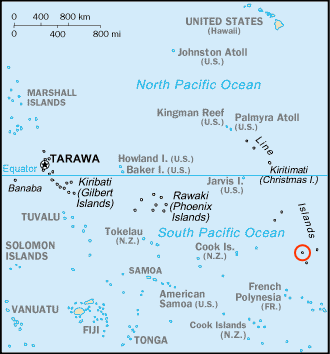
English: Map of Kiribati, adapted version of the post-1995 South Pacific section of Kr-map.png with Vostok Island highlighted |
| Date | |
| Source | https://www.cia.gov/cia/publications/factbook/geos/kr.html |
| Author | Own work, based on original |
| Other versions | original version |
Licensing
This image is in the public domain because it contains materials that originally came from the United States Central Intelligence Agency's World Factbook.
|
 |
| This work was previously under Public Domain, or a Free License. It has been digitally enhanced and/or modified. This derivative work has been (or is hereby) released into the public domain by its author, Telim tor at the German Wikipedia project. This applies worldwide. In some countries this is not legally possible; if so:
|
File history
Click on a date/time to view the file as it appeared at that time.
| Date/Time | Thumbnail | Dimensions | User | Comment | |
|---|---|---|---|---|---|
| current | 10:07, 27 April 2007 | | 330 × 354 (18 KB) | Telim tor | == Information == {{Information |Description= Map of Kiribati, adapted version of the post-1995 South Pacific section of Kr-map.png with with '''Vostok Island''' highlighted |Source=https://www.cia.gov/cia/publications/factbook/geos/kr.html |Date=27th Apr |
File usage
The following pages on the English Wikipedia use this file (pages on other projects are not listed):
Global file usage
The following other wikis use this file:
- Usage on es.wikipedia.org
- Usage on fa.wikipedia.org
- Usage on he.wikipedia.org
- Usage on it.wikipedia.org
- Usage on ko.wikipedia.org
- Usage on lt.wikipedia.org
- Usage on pl.wikipedia.org
- Usage on ru.wikipedia.org