
File:Keyser Formation 522.jpg

Size of this preview: 800 × 600 pixels. Other resolutions: 320 × 240 pixels | 640 × 480 pixels | 1,024 × 768 pixels | 1,280 × 960 pixels | 2,048 × 1,536 pixels.
Original file (2,048 × 1,536 pixels, file size: 1.03 MB, MIME type: image/jpeg)
| This is a file from the Wikimedia Commons. Information from its description page there is shown below. Commons is a freely licensed media file repository. You can help. |
Summary
| Description |
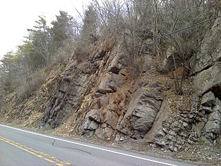
English: Outcrop of the Keyser Formation on U.S. Route 522 in Fulton County, Pennsylvania north of Warfordsburg, facing north. Stratigraphic up is to the left. |
| Date | |
| Source | Own work by the original uploader |
| Author | Jstuby at English Wikipedia |
| Camera location | | View this and other nearby images on: OpenStreetMap |
|---|
Licensing
Jstuby at en.wikipedia, the copyright holder of this work, hereby publishes it under the following license:
| This file is made available under the Creative Commons CC0 1.0 Universal Public Domain Dedication. | |
| The person who associated a work with this deed has dedicated the work to the public domain by waiving all of their rights to the work worldwide under copyright law, including all related and neighboring rights, to the extent allowed by law. You can copy, modify, distribute and perform the work, even for commercial purposes, all without asking permission.
|
Original upload log
The original description page was here. All following user names refer to en.wikipedia.
- 2011-04-05 03:04 Jstuby 2048×1536 (1075949 bytes) Outcrop of the [[Keyser Formation]] on [[U.S. Route 522]] in [[Fulton County, Pennsylvania]] north of Warfordsburg, facing north. Stratigraphic up is to the left. April 2, 2011. {{coords|39|46|38.85|N|78|11|33.37|W}}
File history
Click on a date/time to view the file as it appeared at that time.
| Date/Time | Thumbnail | Dimensions | User | Comment | |
|---|---|---|---|---|---|
| current | 22:25, 23 December 2011 | | 2,048 × 1,536 (1.03 MB) | BotMultichillT | {{BotMoveToCommons|en.wikipedia|year={{subst:CURRENTYEAR}}|month={{subst:CURRENTMONTHNAME}}|day={{subst:CURRENTDAY}}}} == {{int:filedesc}} == {{Information |description={{en|1=Outcrop of the Keyser Formation on [[:en:U.S. Route 5 |
File usage
The following pages on the English Wikipedia use this file (pages on other projects are not listed):