
File:Kashmir region 2004.jpg

Size of this preview: 604 × 599 pixels. Other resolutions: 242 × 240 pixels | 484 × 480 pixels | 774 × 768 pixels | 1,032 × 1,024 pixels | 1,579 × 1,567 pixels.
Original file (1,579 × 1,567 pixels, file size: 1.71 MB, MIME type: image/jpeg)
| This is a file from the Wikimedia Commons. Information from its description page there is shown below. Commons is a freely licensed media file repository. You can help. |
| Description |
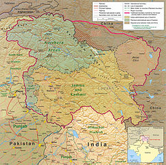
English: Kashmir Region 2004 |
|||
| Date | ||||
| Source | http://www.lib.utexas.edu/maps/middle_east_and_asia/kashmir_region_2004.jpg | |||
| Author | CIA | |||
| Permission (Reusing this file) |
|
|||
| Other versions |
 .jpg)
|


File history
Click on a date/time to view the file as it appeared at that time.
| Date/Time | Thumbnail | Dimensions | User | Comment | |
|---|---|---|---|---|---|
| current | 21:45, 6 June 2010 | | 1,579 × 1,567 (1.71 MB) | Ras67 | slightly rotated and cropped |
| 18:46, 7 March 2006 |  | 1,616 × 1,623 (789 KB) | Jungpionier | Kashmir Region 2004 Source URL: [http://www.lib.utexas.edu/maps/middle_east_and_asia/kashmir_region_2004.jpg]. {{PD-USGov-CIA}} |
File usage
The following pages on the English Wikipedia use this file (pages on other projects are not listed):
- 2014–2015 India–Pakistan border skirmishes
- 2016 Indian Line of Control strike
- 2016 Uri attack
- Article 370 of the Constitution of India
- Asghar Khan
- China–Pakistan border
- Jammu and Kashmir (state)
- Kargilik County
- Khan Mughals
- List of Russian explorers
- Operation Gibraltar
- Tatrinote
- United Kashmir People's National Party
- United Nations Security Council Resolution 47
- United Nations Security Council Resolution 80
- War on terror
- Talk:Bunji Bridge
- Talk:Demchok, Ladakh
- Talk:Indo-Pakistani war of 1965/Archive 9
- Talk:Jammu and Kashmir (state)/Archive 1
- User:Falcaorib
- User:Johnleeds1/Kashmir conflict
- User:Kashmirian
- User:Mehrajmir13
- User:Phoenix B 1of3/Kashmiri Self Determination
- User:Shivansh.ganjoo/sandbox
- User:Traing/Sino-Indian War
- User talk:Kashmirian
- Wikipedia:Top 25 Report/May 25 to 31, 2014
- Wikipedia:VideoWiki/Arundhati Roy
- Wikipedia talk:Noticeboard for India-related topics/Archive 69
Global file usage
The following other wikis use this file:
- Usage on af.wikipedia.org
- Usage on ang.wikipedia.org
- Usage on ar.wikipedia.org
- Usage on arz.wikipedia.org
- Usage on azb.wikipedia.org
- Usage on az.wikipedia.org
- Usage on be-tarask.wikipedia.org
- Usage on be.wikipedia.org
- Usage on bg.wikipedia.org
- Usage on bh.wikipedia.org
- Usage on bn.wikipedia.org
- Usage on br.wikipedia.org
- Usage on ca.wikipedia.org
- Usage on cdo.wikipedia.org
- Usage on ckb.wikipedia.org
- Usage on cs.wikipedia.org
- Usage on da.wikipedia.org
- Usage on de.wikipedia.org
- Usage on de.wikinews.org
- Usage on diq.wikipedia.org
- Usage on el.wikipedia.org
- Usage on en.wikinews.org
- Usage on en.wikisource.org
- Usage on en.wiktionary.org
- Usage on es.wikipedia.org
- Usage on eu.wikipedia.org
View more global usage of this file.