
File:Karte Melchior Hofmann.png

Size of this preview: 782 × 600 pixels. Other resolutions: 313 × 240 pixels | 626 × 480 pixels | 1,001 × 768 pixels | 1,280 × 982 pixels | 1,873 × 1,437 pixels.
Original file (1,873 × 1,437 pixels, file size: 2.67 MB, MIME type: image/png)
| This is a file from the Wikimedia Commons. Information from its description page there is shown below. Commons is a freely licensed media file repository. You can help. |

|
This map image could be re-created using vector graphics as an SVG file. This has several advantages; see Commons:Media for cleanup for more information. If an SVG form of this image is available, please upload it and afterwards replace this template with
{{vector version available|new image name}}.
It is recommended to name the SVG file “Karte Melchior Hofmann.svg”—then the template Vector version available (or Vva) does not need the new image name parameter. |
Summary
| Description |
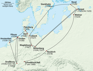
Deutsch: Karte der Reisen von Melchior Hofmann
English: Map of the journeys of Melchior Hoffman |
|
| Date | ||
| Source |
Own work, using
|
|
| Author | NordNordWest | |
| Permission (Reusing this file) |
This file is licensed under the Creative Commons Attribution-Share Alike 3.0 Germany license.
 This file is licensed under the Creative Commons Attribution-Share Alike 3.0 Germany license.
|


|
This map has been made or improved in the German Kartenwerkstatt (Map Lab). You can propose maps to improve as well.
|
File history
Click on a date/time to view the file as it appeared at that time.
| Date/Time | Thumbnail | Dimensions | User | Comment | |
|---|---|---|---|---|---|
| current | 16:50, 23 January 2018 | | 1,873 × 1,437 (2.67 MB) | NordNordWest | upd |
| 16:46, 21 February 2011 |  | 1,873 × 1,437 (2.61 MB) | NordNordWest | upd | |
| 10:11, 25 November 2009 |  | 1,873 × 1,437 (2.61 MB) | NordNordWest | ||
| 19:42, 24 November 2009 |  | 1,873 × 1,437 (2.6 MB) | NordNordWest | == {{int:filedesc}} == {{Information |Description= {{de|Karte der Reisen von Melchior Hofmann}} {{en|Map of the journeys of Melchior Hoffman}} |Source={{Own}}, using * GTOPO-30 Elevation Data by USGS |Dat |
File usage
The following pages on the English Wikipedia use this file (pages on other projects are not listed):
Global file usage
The following other wikis use this file:
- Usage on da.wikipedia.org
- Usage on de.wikipedia.org
- Usage on fr.wikipedia.org
- Usage on fy.wikipedia.org
- Usage on ja.wikipedia.org
- Usage on la.wikipedia.org
- Usage on nl.wikipedia.org
- Usage on pl.wikipedia.org
- Usage on pt.wikipedia.org
- Usage on ru.wikipedia.org