
File:Karte Hamburg Innenstadtkanäle.png
Size of this preview: 523 × 599 pixels. Other resolutions: 210 × 240 pixels | 419 × 480 pixels | 671 × 768 pixels | 894 × 1,024 pixels | 1,764 × 2,020 pixels.
Original file (1,764 × 2,020 pixels, file size: 773 KB, MIME type: image/png)
| This is a file from the Wikimedia Commons. Information from its description page there is shown below. Commons is a freely licensed media file repository. You can help. |
Summary
| Description |
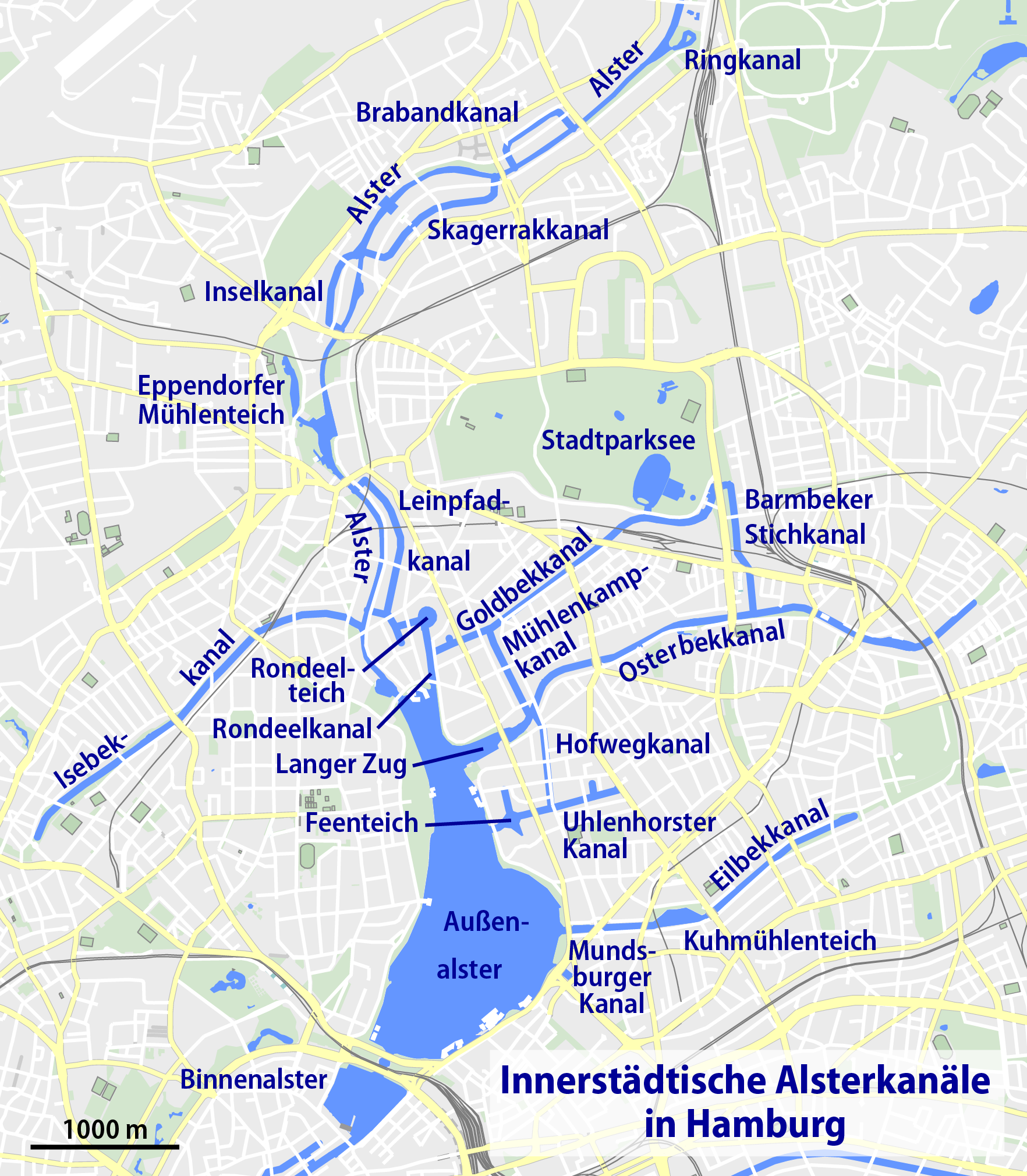
Deutsch: Karte der innerstädtischen Kanäle von Hamburg
English: Map of canals in Hamburg |
| Date | |
| Source | Own work |
| Author | NordNordWest |
| Other versions |
 |

|
This map has been made or improved in the German Kartenwerkstatt (Map Lab). You can propose maps to improve as well.
|
Licensing
| Description |
This map was created from OpenStreetMap project data, collected by the community. This map may be incomplete, and may contain errors. Don't rely solely on it for navigation. |
| Date | (see file history) |
| Source | openstreetmap.org |
| Creator |
OpenStreetMap contributors |
| Permission (Reusing this file) |
OpenStreetMap data and maps are licensed under the Creative Commons Attribution-ShareAlike 2.0 license (CC-BY-SA 2.0). This file is licensed under the Creative Commons Attribution-Share Alike 2.0 Generic license.
|
| Georeferencing | If inappropriate please set warp_status = skip to hide. |
File history
Click on a date/time to view the file as it appeared at that time.
| Date/Time | Thumbnail | Dimensions | User | Comment | |
|---|---|---|---|---|---|
| current | 14:38, 10 January 2020 | | 1,764 × 2,020 (773 KB) | NordNordWest | upd |
| 22:47, 22 May 2014 |  | 1,160 × 1,331 (827 KB) | Ras67 | cropped, ECI-RGB profile preserved | |
| 16:12, 1 February 2011 |  | 1,176 × 1,347 (829 KB) | NordNordWest | upd | |
| 16:48, 29 July 2009 |  | 1,183 × 1,354 (468 KB) | NordNordWest | ||
| 20:31, 28 July 2009 |  | 1,183 × 1,354 (468 KB) | NordNordWest | ||
| 19:55, 28 July 2009 |  | 1,183 × 1,354 (468 KB) | NordNordWest | {{Information |Description= {{de|Karte der innerstädtischen Kanäle von Hamburg}} {{en|Map of canals in Hamburg}} |Source={{Own}} |Date=2009-07-28 |Author={{U|NordNordWest}} |Permission={{OpenStreetMap}} |other_versions= |
File usage
The following pages on the English Wikipedia use this file (pages on other projects are not listed):
Global file usage
The following other wikis use this file:
- Usage on af.wikipedia.org
- Usage on arz.wikipedia.org
- Usage on ca.wikipedia.org
- Usage on da.wikipedia.org
- Usage on de.wikipedia.org
- Isebekkanal
- Osterbek
- Goldbekkanal
- Kanäle in Hamburg
- Leinpfadkanal
- Wikipedia:Kartenwerkstatt/Archiv/2009-07
- Rondeelteich
- Barmbeker Stichkanal
- Benutzer:Aeroid/List DE HH-unmittelbar
- Benutzer:UweRohwedder/hhmaps
- Brabandkanal
- Skagerrakkanal
- Uhlenhorster Kanal
- Wikipedia:Kontor Hamburg/Kanäle
- Inselkanal
- Feenteich
- Rondeelkanal
- Mühlenkampkanal
- Usage on mk.wikipedia.org
- Usage on sr.wikipedia.org
- Usage on www.wikidata.org